Abstract
Landslides are complex natural hazards resulting from interactions among geological, geomorphological, hydrological, climatic and anthropogenic processes. In Sierra Leone, these risks are intensified by rapid urbanisation, environmental degradation, inadequate land-use planning and limited institutional capacity. The 14 August 2017 Regent landslide in the Freetown Peninsula demonstrated the severe consequences of rainfall triggered slope failure interacting with flooding, infrastructure vulnerability and human exposure. This study examines how landslide science, public policy and practical risk reduction measures can be integrated to promote safer and more resilient communities in Sierra Leone. It specifically considers the physical and human drivers of landslide risk, the contribution of inventories, susceptibility mapping, remote sensing, geospatial analysis and rainfall information, and the translation of scientific knowledge into planning, governance and community action. The paper adopts an integrated hazard-exposure-vulnerability-capacity framework and uses the Sierra Leone experience, particularly the Freetown Peninsula, as a case study. It synthesizes evidence from landslide inventories, susceptibility assessments, remote sensing studies, climate risk assessments, disaster risk policies and institutional developments. The analysis considers interactions among rainfall, terrain, land-use change, urbanisation, exposure, vulnerability and institutional capacity. The analysis shows that landslide risk in Sierra Leone is produced by the interaction of physical susceptibility and accumulated social vulnerability. The 2017 Regent event illustrates the importance of considering cascading processes, including landslide material, drainage networks, flood pathways and downstream exposure. Although scientific research, geospatial technologies and national disaster risk institutions are doing their utmost, gaps remain in risk communication, data management, community inclusion, infrastructure resilience and coordination between policy and implementation. Effective landslide risk reduction requires a shift from reactive disaster response towards integrated, anticipatory and community-centered resilience. Connecting geoscience, remote sensing, engineering, climate science, spatial planning, ecosystem management, governance and community knowledge can help ensure that scientific evidence directly informs development and risk reduction decisions.
Keywords
Landslide Risk, Sierra Leone, Freetown Peninsula, Landslide Susceptibility, Climate Change, Urbanisation,
Disaster Risk Reduction, Community Resilience
1. Background and Rationale
Landslides are among the most complex and locally destructive natural hazards, emerging from the interaction of geological, geomorphological, hydrological, climatic and anthropogenic processes. Their consequences are amplified where rapid urbanisation, environmental degradation, inadequate land-use planning, infrastructure deficits and limited institutional capacity converge with increasingly variable and intense rainfall. Contemporary landslide risk management therefore requires a transition from predominantly reactive disaster response towards integrated proactive approaches that connect hazard science, vulnerability assessment, spatial planning, governance, early warning, engineering, ecosystem management and community action
| [2] | Fell, R., Corominas, J., Bonnard, C., Cascini, L., Leroi, E. and Savage, W. Z. Guidelines for landslide susceptibility, hazard and risk zoning for land-use planning, Engineering Geology. 2008, 102(3-4), 85-98.
https://doi.org/10.1016/j.enggeo.2008.03.022 |
| [16] | United Nations Office for Disaster Risk Reduction (UNDRR) Sendai Framework for Disaster Risk Reduction 2015-2030. Geneva: UNDRR. 2015. |
[2, 16]
.
Sierra Leone provides a compelling case through which to examine this transition. The country is exposed to multiple interacting climate and environmental hazards, while Freetown and other rapidly expanding settlements increasingly occupy environmentally sensitive terrain. The Freetown Peninsula is particularly susceptible because of its steep mountainous topography, deeply weathered geological materials, intense seasonal rainfall and highly dynamic urban environment. The catastrophic 14
th August 2017 Regent landslide demonstrated the consequences of this hazard exposure interaction at an exceptional scale. Approximately 300,000 m
3 of material mass collapsed from the hillslope and subsequently interacted with floodwater, producing a sediment laden flow that travelled approximately 6 km towards the coast. The event destroyed nearly 400 buildings, affected approximately 5,000 people and caused an estimated 1,100 fatalities
| [12] | Redshaw, P., Boon, D., Campbell, G., Willis, M., Mattai, J., Free, M., Jordan, C., Kemp, S. J., Morley, A. and Thomas, M. The 2017 Regent Landslide, Freetown Peninsula, Sierra Leone’, Quarterly Journal of Engineering Geology and Hydrogeology. 2019, 52(4), 435-444.
https://doi.org/10.1144/qjegh2018-187 |
[12]
.
Importantly, the 2017 disaster was not an isolated geomorphological anomaly. Geomorphological investigations have identified evidence of numerous prehistoric and historical landslides across the Freetown Peninsula, demonstrating that the landscape possesses a persistent landslide susceptibility that predates contemporary urban development
| [12] | Redshaw, P., Boon, D., Campbell, G., Willis, M., Mattai, J., Free, M., Jordan, C., Kemp, S. J., Morley, A. and Thomas, M. The 2017 Regent Landslide, Freetown Peninsula, Sierra Leone’, Quarterly Journal of Engineering Geology and Hydrogeology. 2019, 52(4), 435-444.
https://doi.org/10.1144/qjegh2018-187 |
[12]
. The central challenge, therefore, is not merely determining where landslides occur, but understanding why risk becomes concentrated in specific places and how scientific knowledge can be converted into practical decisions that reduce exposure and vulnerability.
This paper argues that Sierra Leone's landslide challenge should be understood through an integrated hazard-exposure-vulnerability-capacity framework. Such an approach recognises that a landslide becomes a disaster not simply because a slope fails, but because people, buildings, infrastructure, livelihoods and critical services are exposed to hazard processes within contexts of varying vulnerability and preparedness.
1.1. Aim and Objectives
The overarching aim of this study is to examine how landslide science, public policy and practical risk reduction measures can be integrated to build safer and more resilient communities in Sierra Leone.
Specifically, the study seeks to:
1) examine the principal physical and human drivers of landslide risk in Sierra Leone, with particular emphasis on the Freetown Peninsula.
2) assess the contribution of landslide inventories, susceptibility mapping, remote sensing, geospatial analysis and rainfall information to landslide risk understanding.
3) examine the extent to which scientific knowledge is translated into land-use planning, disaster risk reduction, infrastructure management and climate change adaptation.
4) explore the role of institutions and communities in converting hazard information into proactive preventive actions.
5) propose an integrated framework for moving from landslide prediction and post-disaster response towards anticipatory, risk informed and community centered resilience.
1.2. Conceptual Framework
The study adopts the proposition that landslide risk is produced through the interaction of hazard, exposure, vulnerability and coping / adaptive capacity. In short,
Landslide Risk = Hazard × Exposure × Vulnerability, conditioned by Capacity and Resilience.
This framing is consistent with contemporary disaster risk thinking, particularly the Sendai Framework for Disaster Risk Reduction, which places understanding disaster risk at the center of prevention and resilience building
| [16] | United Nations Office for Disaster Risk Reduction (UNDRR) Sendai Framework for Disaster Risk Reduction 2015-2030. Geneva: UNDRR. 2015. |
[16]
. It also reflects the broader climate change risk perspective in which hazards interact with exposure and vulnerability to produce impacts
| [5] | Intergovernmental Panel on Climate Change (IPCC) Climate Change 2022: Impacts, Adaptation and Vulnerability. Cross-Chapter Paper 5: Mountains. Contribution of Working Group II to the Sixth Assessment Report of the Intergovernmental Panel on Climate Change. Cambridge: Cambridge University Press. 2022, 13-31. https://doi.org/10.1017/9781009325844 |
[5]
.
Within this framework, landslide hazard refers to the probability and characteristics of slope failure, including its magnitude, frequency, spatial distribution and potential run-out. Exposure concerns the people, settlements, infrastructure, economic assets and ecosystems located within potentially affected areas. Vulnerability encompasses the physical, social, economic, environmental and institutional conditions that determine the severity of impacts. Capacity, meanwhile, includes the ability of communities, institutions and infrastructure systems to anticipate, withstand, respond to and recover from landslide events.
This distinction is particularly important for Sierra Leone. A technically sophisticated susceptibility map has limited value if it does not influence where people build houses, where roads are constructed, how drainage is designed, how forests are managed, or when communities receive warnings. Consequently, the paper conceptualises resilience not as a purely engineering outcome, but as the product of knowledge, institutions, infrastructure, ecosystems, governance and community agency working together.
2. The Sierra Leone Experience: From Hazard to Disaster Risk
The Freetown Peninsula illustrates the interaction between natural processes and rapidly changing human systems and settlements. Steep slopes and valleys provide physical conditions for rainfall triggered landslides, while intense seasonal rainfall can increase soil moisture, soil pore-space water pressure and slope instability. At the same time, population growth, settlement expansion, change in landcover and development pressure has increased exposure and modified steep slopes, drainage conditions and coastal low-lying planes.
The 2017 Regent event provides a particularly important scientific and policy lesson. Redshaw et al.
| [12] | Redshaw, P., Boon, D., Campbell, G., Willis, M., Mattai, J., Free, M., Jordan, C., Kemp, S. J., Morley, A. and Thomas, M. The 2017 Regent Landslide, Freetown Peninsula, Sierra Leone’, Quarterly Journal of Engineering Geology and Hydrogeology. 2019, 52(4), 435-444.
https://doi.org/10.1144/qjegh2018-187 |
[12]
characterised the failure as a two-stage rainfall triggered landslide followed by a channelised debris-laden flood. The event demonstrated how slope failure can rapidly evolve into a cascading hazard, whereby landslide material interacts with surface water and drainage systems to extend impacts well beyond the initial failure zone.
This cascading dimension has major implications for risk assessment. Conventional slope stability assessments that focus exclusively on the initiation point may underestimate downstream consequences. For Freetown and comparable rapidly urbanising cities, landslide risk assessments therefore need to incorporate source areas, flow paths, drainage networks, valley floor exposure and downstream infrastructure within a whole catchment perspective.
Recent research also demonstrates the potential for geospatial and remote sensing techniques to strengthen landslide susceptibility assessment in Sierra Leone. Studies using archived inventories and satellite based Small Baseline Subset Interferometric Synthetic Aperture Radar (SBAS-InSAR) approaches have explored the predictive capacity of landslide inventories for susceptibility modelling in Freetown, Western Area, demonstrating the value of integrating historical records with remotely sensed deformation information
| [9] | Kursah, M. B., Wang, Y., Bayoh, H. D., et al. A comparative study on the predictive ability of archived and SBAS-InSAR inventories for landslide susceptibility using frequency ratio model in Western Area, Sierra Leone, Environmental Earth Sciences. 2021, 80 (1), 387.
https://doi.org/10.1007/s12665-021-09663-x |
[9]
. Other research has compared susceptibility mapping approaches for the Freetown Peninsula and emphasised the importance of identifying conditioning and triggering factors as a foundation for disaster risk management
| [13] | Restrepo Ruiz, E., Lateltin, O., Linero Molina, C. and Hölbling, D. Comparing two approaches for landslide susceptibility mapping - a case study in Freetown, Sierra Leone, Proceedings of the XIII International Symposium on Landslides, Cartagena, Colombia. 2021.
https://www.issmge.org/uploads/publications/105/106/ISL2020-14.pdf |
[13]
.
These developments provide an important opportunity to leverage on. Sierra Leone can increasingly move towards data driven, spatially explicit and anticipatory landslide risk management. However, the scientific challenge is closely matched by an institutional challenge, ensuring that scientific information becomes accessible, trusted and actionable for policymakers, planners, engineers, emergency managers and local communities.
2.1. Climate Change, Urbanisation and the Changing Risk Landscape
Climate change adds another dimension and layer to the landslide risk problem. Sierra Leone's National Adaptation Plan recognises increasing vulnerability associated with changing rainfall patterns, flooding, mudslides and other climate-related hazards, while emphasising the importance of strengthening adaptive capacity and integrating adaptation into national and sectoral planning
| [4] | GoSL National Adaptation Plan. Freetown: Government of Sierra Leone. 2021, 14-70. |
| [15] | United Nations Development Programme (UNDP) National Adaptation Plan 2021. Sierra Leone: UNDP. 2022. |
[4, 15]
. More recent climate policy assessments similarly identify increasingly erratic rainfall and intensified precipitation events as important climate risks for Sierra Leone and emphasise the need for more forward thinking and rigorous disaster risk assessments
.
The relationship between climate change and landslide occurrence should therefore be interpreted with caution rather than reduced to the simplistic assumption that climate change directly causes landslides. Instead, changes in the frequency, intensity, duration and seasonality of rainfall may alter landslide triggering conditions by interacting with pre-existing geological, geomorphological and hydrological characteristics that determine slope susceptibility
| [5] | Intergovernmental Panel on Climate Change (IPCC) Climate Change 2022: Impacts, Adaptation and Vulnerability. Cross-Chapter Paper 5: Mountains. Contribution of Working Group II to the Sixth Assessment Report of the Intergovernmental Panel on Climate Change. Cambridge: Cambridge University Press. 2022, 13-31. https://doi.org/10.1017/9781009325844 |
| [6] | IPCC Climate Change 2021: The Physical Science Basis, Chapter 12 - Climate Change Information for Regional Impact and for Risk Assessment. Contribution of Working Group I to the Sixth Assessment Report of the Intergovernmental Panel on Climate Change. Cambridge: Cambridge University Press. 2021, 16-29. https://doi.org/10.1017/9781009157896 |
| [17] | U. S Geological Survey (USGS) Overview of Rainfall-Induced Landslides. 2018, Available from:
https://www.usgs.gov/programs/landslide-hazards/science/overview-rainfall-induced-landslides (accessed 2 May 2026). |
[5, 6, 17]
. These climatic influences may be further amplified by land-use and land-cover change, altered drainage conditions and increasing human exposure on unstable slopes. Consequently, climate change is better understood as a potential modifier of landslide hazard within a coupled environmental and socio-economic system, rather than as an independent cause of slope failure. Recognising this distinction is essential for robust scientific attribution, credible risk communication and the design of effective climate adaptation and landslide risk reduction strategies
| [1] | Bogaard, T. and Greco, R. Invited perspectives: Hydrological perspectives on precipitation intensity-duration thresholds for landslide initiation: proposing hydro-meteorological thresholds, Natural Hazards and Earth System Sciences. 2018, 18 (1), 31-39. https://doi.org/10.5194/nhess-18-31-2018 |
| [6] | IPCC Climate Change 2021: The Physical Science Basis, Chapter 12 - Climate Change Information for Regional Impact and for Risk Assessment. Contribution of Working Group I to the Sixth Assessment Report of the Intergovernmental Panel on Climate Change. Cambridge: Cambridge University Press. 2021, 16-29. https://doi.org/10.1017/9781009157896 |
| [10] | Monsieurs, E., Dewitte, O. and Demoulin, A. A susceptibility-based rainfall threshold approach for landslide occurrence, Natural Hazards and Earth System Sciences. 2019, 19(1) 775-789. https://doi.org/10.5194/nhess-19-775-2019 |
[1, 6, 10]
.
Urbanisation can further amplify these interactions. Where settlements expand into steep terrain without adequate geotechnical assessment, drainage, slope management and enforcement of land-use controls, exposure increases even if the underlying physical hazard remains unchanged. Thus, urban growth is not inherently a disaster risk driver; poorly risk informed urban growth is. For Sierra Leone, this creates an urgent planning question: can future urban development be directed towards safer locations while simultaneously upgrading existing high-risk settlements? The answer requires stronger integration between policy decisions, geoscience, urban planning, environmental management and disaster risk governance.
2.2. From Policy to Practice
Sierra Leone has made important institutional progress in disaster risk governance. The National Disaster Management Agency Act, 2020 established the National Disaster Management Agency (NDMA) and provides a statutory foundation for national disaster management and community capacity development. The NDMA's current mandate encompasses disaster prevention, disaster risk reduction, climate risk management, information management, preparedness, response and early warning. The country's disaster risk management policy architecture also explicitly recognises the importance of prevention, mitigation, decentralisation, community participation, data and information management, and the integration of climate change considerations into disaster risk management
| [3] | Government of Sierra Leone (GoSL) National Disaster Management Agency Act, 2020. Act No. 3 of 2020. Freetown: Government of Sierra Leone. 2020, 13-35. |
| [4] | GoSL National Adaptation Plan. Freetown: Government of Sierra Leone. 2021, 14-70. |
| [11] | National Disaster Management Agency (NDMA) Sierra Leone Risk Management Policy for Sierra Leone. Freetown: National Disaster Management Agency. 2024, 20-68. |
[3, 4, 11]
.
Nevertheless, an important implementation gap remains between policy intent and risk-informed practice. Recent research in Freetown indicates that although disaster risk management and climate change adaptation policies exist, their effectiveness is constrained by issues including community inclusion, capacity, financial mechanisms, data management, risk communication and resilient infrastructure
| [14] | Sam-Mbomah, E., Chmutina, K., Smith, A., Goodall, S. and Bosher, L. Investigating disaster risk management and climate change adaptation effectiveness in Freetown, Sierra Leone, Jàmbá: Journal of Disaster Risk Studies. 2025, 17(1), 7-15. https://doi.org/10.4102/jamba.v17i1.1904 |
[14]
. Similarly, recent assessments identify fragmented, incomplete and outdated vulnerability information as a significant obstacle to mainstreaming climate and disaster risk into development decisions. The institutional fragmentation of responsibilities across land-use planning, infrastructure, environmental management and disaster risk management further complicates preventive action
| [7] | International Monetary Fund (IMF) Sierra Leone: Third Review Under the Extended Credit Facility Arrangement, Requests for Waivers of Nonobservance of Performance Criteria, Modification of Performance Criteria, and Request for an Arrangement Under the Resilience and Sustainability Facility. Washington, DC: International Monetary Fund. 2026, 18-53. |
[7]
. The implication is profound. The next frontier of landslide risk reduction in Sierra Leone will not simply be generating more scientific information but improving on the interface between knowledge and decision-making.
2.3. An Integrated Landslide Resilience Framework
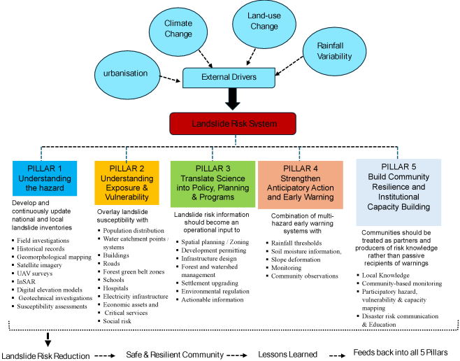
Drawing upon the Sierra Leone experience, this paper proposes a five-pillar Integrated Landslide Resilience Framework as indicated in
Figure 1.
Figure 1. Five-pillar Integrated Landslide Resilience Framework.
2.4. Discussion: From Prediction to Prevention
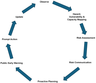
This paper asserts that landslide resilience should be measured by the capacity to prevent disasters through proactive risk reduction, rather than merely by the effectiveness of post-failure response. The Sierra Leone experience demonstrates that high impact landslides occur at the intersection of physical susceptibility and accumulated social vulnerability. Consequently, engineering interventions alone will not eliminate risk. Nor will hazard maps, early warning systems or policy documents achieve their intended outcomes in isolation. A resilient landslide risk management system should instead function as a continuous knowledge-to-action cycle as depicted in
Figure 2.
Figure 2. Continuous knowledge-to-action cycle.
Such a cycle creates a bridge between research and implementation. It also provides a mechanism through which lessons from previous disasters can improve future policy and planning.
This approach is consistent with international disaster risk priorities under the Sendai Framework, particularly the emphasis on understanding disaster risk, strengthening disaster risk governance, investing in resilience and enhancing disaster preparedness for effective response and recovery
| [16] | United Nations Office for Disaster Risk Reduction (UNDRR) Sendai Framework for Disaster Risk Reduction 2015-2030. Geneva: UNDRR. 2015. |
[16]
. It is also aligned with contemporary climate adaptation approaches that place locally grounded, inclusive, and forward-looking risk management at the heart of sustainable resilience building
| [5] | Intergovernmental Panel on Climate Change (IPCC) Climate Change 2022: Impacts, Adaptation and Vulnerability. Cross-Chapter Paper 5: Mountains. Contribution of Working Group II to the Sixth Assessment Report of the Intergovernmental Panel on Climate Change. Cambridge: Cambridge University Press. 2022, 13-31. https://doi.org/10.1017/9781009325844 |
[5]
.
2.5. International Significance and Transferability
Although the case study is Sierra Leone, the lessons have wider relevance for rapidly urbanising cities across West Africa, sub-Saharan Africa and other tropical mountainous regions. Many cities face the same combination of intense rainfall, steep terrain, rapid population growth, informal development, limited geotechnical data, environmental degradation and constrained institutional resources.
The Sierra Leone experience therefore provides an opportunity to demonstrate that effective landslide risk reduction does not necessarily depend on highly sophisticated technologies alone. Rather, resilience can emerge from combining appropriate technology with strong institutions, accessible scientific information, participatory governance and risk sensitive development planning with the local communities being at the gamut of these initiatives.
This paper consequently advances a practical proposition for the international landslide community: the most valuable landslide science is science that changes decisions. A susceptibility map that informs a zoning decision, a rainfall threshold that triggers an evacuation, a community observation that improves an early warning system, or a geotechnical assessment that prevents unsafe development may have greater risk reduction value than a technically sophisticated analysis that never reaches policymakers.
3. Conclusion
Sierra Leone's experience demonstrates that landslide risk is simultaneously a scientific, environmental, engineering, social and governance challenge. The 2017 Regent disaster exposed the devastating consequences of rainfall triggered slope failure interacting with downstream flooding, settlement exposure and infrastructure vulnerability. Subsequent scientific research has strengthened understanding of the Freetown Peninsula's susceptibility, while national institutions and policies have created an increasingly important foundation for disaster risk reduction.
The remaining challenge and nuance are to close the gap between knowing risk and acting on risk. This paper therefore calls for a transition to change the narrative from fragmented hazard management towards an integrated landslide resilience paradigm in which geoscience, remote sensing, geotechnical engineering, climate science, spatial planning, ecosystem management, public policy and community knowledge are systematically connected.
For Sierra Leone, the strategic objective should not simply be to predict the next landslide. It should be to create the institutional, scientific and social capacity to ensure that when a dangerous slope is identified, the right people know, the right authorities act, development decisions reflect the evidence, and communities possess the capacity to protect themselves.
The Sierra Leone experience thus offers an internationally relevant lesson that, resilient communities are built when landslide science moves beyond diagnosis and becomes embedded in everyday decisions about where and how societies live, build, plan and invest.
Abbreviations
GoSL | Government of Sierra Leone |
NDMA | National Disaster Management Agency |
SBAS-InSAR | Small Baseline Subset Interferometric Synthetic Aperture Radar |
Author Contributions
Edwin Sam-Mbomah: Conceptualization, Data curation, Formal Analysis, Methodology, Resources, Writing – original draft
Conflicts of Interest
The author declares no conflicts of interest.
References
| [1] |
Bogaard, T. and Greco, R. Invited perspectives: Hydrological perspectives on precipitation intensity-duration thresholds for landslide initiation: proposing hydro-meteorological thresholds, Natural Hazards and Earth System Sciences. 2018, 18 (1), 31-39.
https://doi.org/10.5194/nhess-18-31-2018
|
| [2] |
Fell, R., Corominas, J., Bonnard, C., Cascini, L., Leroi, E. and Savage, W. Z. Guidelines for landslide susceptibility, hazard and risk zoning for land-use planning, Engineering Geology. 2008, 102(3-4), 85-98.
https://doi.org/10.1016/j.enggeo.2008.03.022
|
| [3] |
Government of Sierra Leone (GoSL) National Disaster Management Agency Act, 2020. Act No. 3 of 2020. Freetown: Government of Sierra Leone. 2020, 13-35.
|
| [4] |
GoSL National Adaptation Plan. Freetown: Government of Sierra Leone. 2021, 14-70.
|
| [5] |
Intergovernmental Panel on Climate Change (IPCC) Climate Change 2022: Impacts, Adaptation and Vulnerability. Cross-Chapter Paper 5: Mountains. Contribution of Working Group II to the Sixth Assessment Report of the Intergovernmental Panel on Climate Change. Cambridge: Cambridge University Press. 2022, 13-31.
https://doi.org/10.1017/9781009325844
|
| [6] |
IPCC Climate Change 2021: The Physical Science Basis, Chapter 12 - Climate Change Information for Regional Impact and for Risk Assessment. Contribution of Working Group I to the Sixth Assessment Report of the Intergovernmental Panel on Climate Change. Cambridge: Cambridge University Press. 2021, 16-29.
https://doi.org/10.1017/9781009157896
|
| [7] |
International Monetary Fund (IMF) Sierra Leone: Third Review Under the Extended Credit Facility Arrangement, Requests for Waivers of Nonobservance of Performance Criteria, Modification of Performance Criteria, and Request for an Arrangement Under the Resilience and Sustainability Facility. Washington, DC: International Monetary Fund. 2026, 18-53.
|
| [8] |
International Monetary Fund (IMF) Sierra Leone: Technical Assistance Report—Climate Policy Diagnostic. Washington, DC: IMF. 2024, 2024 (105), 13-73,
https://doi.org/10.5089/9798400294846.019
|
| [9] |
Kursah, M. B., Wang, Y., Bayoh, H. D., et al. A comparative study on the predictive ability of archived and SBAS-InSAR inventories for landslide susceptibility using frequency ratio model in Western Area, Sierra Leone, Environmental Earth Sciences. 2021, 80 (1), 387.
https://doi.org/10.1007/s12665-021-09663-x
|
| [10] |
Monsieurs, E., Dewitte, O. and Demoulin, A. A susceptibility-based rainfall threshold approach for landslide occurrence, Natural Hazards and Earth System Sciences. 2019, 19(1) 775-789.
https://doi.org/10.5194/nhess-19-775-2019
|
| [11] |
National Disaster Management Agency (NDMA) Sierra Leone Risk Management Policy for Sierra Leone. Freetown: National Disaster Management Agency. 2024, 20-68.
|
| [12] |
Redshaw, P., Boon, D., Campbell, G., Willis, M., Mattai, J., Free, M., Jordan, C., Kemp, S. J., Morley, A. and Thomas, M. The 2017 Regent Landslide, Freetown Peninsula, Sierra Leone’, Quarterly Journal of Engineering Geology and Hydrogeology. 2019, 52(4), 435-444.
https://doi.org/10.1144/qjegh2018-187
|
| [13] |
Restrepo Ruiz, E., Lateltin, O., Linero Molina, C. and Hölbling, D. Comparing two approaches for landslide susceptibility mapping - a case study in Freetown, Sierra Leone, Proceedings of the XIII International Symposium on Landslides, Cartagena, Colombia. 2021.
https://www.issmge.org/uploads/publications/105/106/ISL2020-14.pdf
|
| [14] |
Sam-Mbomah, E., Chmutina, K., Smith, A., Goodall, S. and Bosher, L. Investigating disaster risk management and climate change adaptation effectiveness in Freetown, Sierra Leone, Jàmbá: Journal of Disaster Risk Studies. 2025, 17(1), 7-15.
https://doi.org/10.4102/jamba.v17i1.1904
|
| [15] |
United Nations Development Programme (UNDP) National Adaptation Plan 2021. Sierra Leone: UNDP. 2022.
|
| [16] |
United Nations Office for Disaster Risk Reduction (UNDRR) Sendai Framework for Disaster Risk Reduction 2015-2030. Geneva: UNDRR. 2015.
|
| [17] |
U. S Geological Survey (USGS) Overview of Rainfall-Induced Landslides. 2018, Available from:
https://www.usgs.gov/programs/landslide-hazards/science/overview-rainfall-induced-landslides
(accessed 2 May 2026).
|
Cite This Article
-
APA Style
Sam-Mbomah, E. (2026). Understanding Landslide Risk, Building Resilience: Integrating Science, Policy, and Practice for Safer Communities: The Sierra Leone Experience. American Journal of Environmental Science and Engineering, 10(4), 137-142. https://doi.org/10.11648/j.ajese.20261004.13
 Copy
|
 Download
ACS Style
Sam-Mbomah, E. Understanding Landslide Risk, Building Resilience: Integrating Science, Policy, and Practice for Safer Communities: The Sierra Leone Experience. Am. J. Environ. Sci. Eng. 2026, 10(4), 137-142. doi: 10.11648/j.ajese.20261004.13
Copy
|
Download
AMA Style
Sam-Mbomah E. Understanding Landslide Risk, Building Resilience: Integrating Science, Policy, and Practice for Safer Communities: The Sierra Leone Experience. Am J Environ Sci Eng. 2026;10(4):137-142. doi: 10.11648/j.ajese.20261004.13
Copy
|
Download
-
@article{10.11648/j.ajese.20261004.13,
  author = {Edwin Sam-Mbomah},
  title = {Understanding Landslide Risk, Building Resilience: Integrating Science, Policy, and Practice for Safer Communities: The Sierra Leone Experience},
  journal = {American Journal of Environmental Science and Engineering},
  volume = {10},
  number = {4},
  pages = {137-142},
  doi = {10.11648/j.ajese.20261004.13},
  url = {https://doi.org/10.11648/j.ajese.20261004.13},
  eprint = {https://article.sciencepublishinggroup.com/pdf/10.11648.j.ajese.20261004.13},
  abstract = {Landslides are complex natural hazards resulting from interactions among geological, geomorphological, hydrological, climatic and anthropogenic processes. In Sierra Leone, these risks are intensified by rapid urbanisation, environmental degradation, inadequate land-use planning and limited institutional capacity. The 14 August 2017 Regent landslide in the Freetown Peninsula demonstrated the severe consequences of rainfall triggered slope failure interacting with flooding, infrastructure vulnerability and human exposure. This study examines how landslide science, public policy and practical risk reduction measures can be integrated to promote safer and more resilient communities in Sierra Leone. It specifically considers the physical and human drivers of landslide risk, the contribution of inventories, susceptibility mapping, remote sensing, geospatial analysis and rainfall information, and the translation of scientific knowledge into planning, governance and community action. The paper adopts an integrated hazard-exposure-vulnerability-capacity framework and uses the Sierra Leone experience, particularly the Freetown Peninsula, as a case study. It synthesizes evidence from landslide inventories, susceptibility assessments, remote sensing studies, climate risk assessments, disaster risk policies and institutional developments. The analysis considers interactions among rainfall, terrain, land-use change, urbanisation, exposure, vulnerability and institutional capacity. The analysis shows that landslide risk in Sierra Leone is produced by the interaction of physical susceptibility and accumulated social vulnerability. The 2017 Regent event illustrates the importance of considering cascading processes, including landslide material, drainage networks, flood pathways and downstream exposure. Although scientific research, geospatial technologies and national disaster risk institutions are doing their utmost, gaps remain in risk communication, data management, community inclusion, infrastructure resilience and coordination between policy and implementation. Effective landslide risk reduction requires a shift from reactive disaster response towards integrated, anticipatory and community-centered resilience. Connecting geoscience, remote sensing, engineering, climate science, spatial planning, ecosystem management, governance and community knowledge can help ensure that scientific evidence directly informs development and risk reduction decisions.},
 year = {2026}
}
Copy
|
Download
-
TY  - JOUR
T1  - Understanding Landslide Risk, Building Resilience: Integrating Science, Policy, and Practice for Safer Communities: The Sierra Leone Experience
AU  - Edwin Sam-Mbomah
Y1  - 2026/10/20
PY  - 2026
N1  - https://doi.org/10.11648/j.ajese.20261004.13
DO  - 10.11648/j.ajese.20261004.13
T2  - American Journal of Environmental Science and Engineering
JF  - American Journal of Environmental Science and Engineering
JO  - American Journal of Environmental Science and Engineering
SP  - 137
EP  - 142
PB  - Science Publishing Group
SN  - 2578-7993
UR  - https://doi.org/10.11648/j.ajese.20261004.13
AB  - Landslides are complex natural hazards resulting from interactions among geological, geomorphological, hydrological, climatic and anthropogenic processes. In Sierra Leone, these risks are intensified by rapid urbanisation, environmental degradation, inadequate land-use planning and limited institutional capacity. The 14 August 2017 Regent landslide in the Freetown Peninsula demonstrated the severe consequences of rainfall triggered slope failure interacting with flooding, infrastructure vulnerability and human exposure. This study examines how landslide science, public policy and practical risk reduction measures can be integrated to promote safer and more resilient communities in Sierra Leone. It specifically considers the physical and human drivers of landslide risk, the contribution of inventories, susceptibility mapping, remote sensing, geospatial analysis and rainfall information, and the translation of scientific knowledge into planning, governance and community action. The paper adopts an integrated hazard-exposure-vulnerability-capacity framework and uses the Sierra Leone experience, particularly the Freetown Peninsula, as a case study. It synthesizes evidence from landslide inventories, susceptibility assessments, remote sensing studies, climate risk assessments, disaster risk policies and institutional developments. The analysis considers interactions among rainfall, terrain, land-use change, urbanisation, exposure, vulnerability and institutional capacity. The analysis shows that landslide risk in Sierra Leone is produced by the interaction of physical susceptibility and accumulated social vulnerability. The 2017 Regent event illustrates the importance of considering cascading processes, including landslide material, drainage networks, flood pathways and downstream exposure. Although scientific research, geospatial technologies and national disaster risk institutions are doing their utmost, gaps remain in risk communication, data management, community inclusion, infrastructure resilience and coordination between policy and implementation. Effective landslide risk reduction requires a shift from reactive disaster response towards integrated, anticipatory and community-centered resilience. Connecting geoscience, remote sensing, engineering, climate science, spatial planning, ecosystem management, governance and community knowledge can help ensure that scientific evidence directly informs development and risk reduction decisions.
VL  - 10
IS  - 4
ER  -
Copy
|
Download





 Share This Article
 Twitter
 Linked In
 Facebook