Access to safe and sustainable water resources remains a major challenge in many sub-Saharan African urban centers, particularly in rapidly growing towns characterized by insufficient hydraulic infrastructure. This study investigates household water supply modes and evaluates spring productivity in the Foumban locality, situated in the Bamoun Plateau of the Western Highlands of Cameroon. It combines socio-economic surveys, hydrometric monitoring, geostatistical techniques, and multivariate statistical analyses to better understand the dependence of local populations on groundwater resources and the hydrodynamic behavior of springs in fractured basement aquifers. More than 500 households distributed across 13 localities were surveyed between 2014 and 2016 to assess water accessibility, consumption patterns, and socio-economic constraints related to water supply. In parallel, monthly discharge measurements were conducted on ten representative springs over one hydrological year using the volumetric gauging method. The results reveal that groundwater constitutes the principal source of domestic water supply in Foumban. During the dry season, 50% of households depend on springs, whereas 22.8%, 16%, 6.7%, and 4.5% rely respectively on CAMWATER, wells, boreholes, and rivers. In the rainy season, spring water remains dominant (39.7%), followed by CAMWATER (22.1%), wells (14.4%), rainwater (12.2%), boreholes (7.7%), and rivers (3.9%). Most households travel considerable distances to fetch water, reflecting the inadequacy of the public distribution network and the precarious socio-economic conditions of the population. Water-related diseases, notably typhoid and malaria, remain recurrent and are associated with the consumption of untreated water. Spring discharges vary significantly both spatially and temporally, ranging from 0.11 to 8.40 m³/h, with the most productive springs generally located along major fracture. Spring discharge variations closely follow seasonal rainfall patterns, although delayed recharge responses indicate heterogeneous aquifer behavior. Principal Component Analysis, Hierarchical Cluster Analysis, and semi-variogram modeling reveal the coexistence of shallow weathered aquifers and deep fractured aquifers characterized by strong spatial heterogeneity. These findings provide valuable scientific information for sustainable groundwater management, urban water planning, and socio-economic development in Foumban and other basement regions of tropical Africa.
| Published in | Hydrology (Volume 14, Issue 2) |
| DOI | 10.11648/j.hyd.20261402.11 |
| Page(s) | 22-36 |
| Creative Commons |
This is an Open Access article, distributed under the terms of the Creative Commons Attribution 4.0 International License (http://creativecommons.org/licenses/by/4.0/), which permits unrestricted use, distribution and reproduction in any medium or format, provided the original work is properly cited. |
| Copyright |
Copyright © The Author(s), 2026. Published by Science Publishing Group |
Bamoun Plateau, Groundwater, Water Supply, Multivariate Statistical Analysis, Socio-economic Development
Locality | Springs | Longitude | Latitude | Altitude (m) | Description of the spring environment |
|---|---|---|---|---|---|
Njissé | S1 | E010°53′ 13.3″ | N05°43′26,7″ | 1169 | Fitted spring equipped with a siphon, located under a tree; presence of tree-lined and verdant vegetation. |
Njiyouom | S2 | E010°53′28,6″ | N05°43′28,7″ | 1159 | Fitted spring equipped with two siphons. There is and outcrop upstream of the spring and a nearby swamp. |
Koukwuet | S3 | E010°53′34,7″ | N05°43′42,8″ | 1156 | Fitted spring equipped with two siphons. There is a coffee plantation nearby. This spring is widely used by the population. |
Fentain | S4 | E010°54′32,6″ | N05°43′43,7″ | 1140 | Fitted spring equipped with a siphon. It is located behind the Kueka hospital. We note the presence of palm trees nearby. |
Njindaré | S5 | E010°53′00,0″ | N05°43′58,5″ | 1143 | Fitted spring equipped with a siphon situated behind the Technical High School. There are trees and latrines in the surroundings. |
Manka | S6 | E010°54′29,9″ | N05°43′59,9″ | 1132 | Fitted spring equipped with a siphon situated behind Beau-regard Hotel. There are houses and latrines around. It is poorly maintained. |
Fomchout | S7 | E010°53′03,2″ | N05°43′31,3″ | 1173 | Fitted spring equipped with two siphons. Situated near the passenger station, facing the municipal lake and in the swamp. It utilized by almost all the populations of Foumban. |
Njintout | S8 | E010°53′03,2″ | N05°44′00,6″ | 1182 | Fitted spring equipped with a siphon. It is situated behind Ngapout Foundation. There are house and latrines around. |
Kounga | S9 | E010°52′57,2″ | N05°43′46,9″ | 1176 | Fitted spring equipped with a siphon situated behind the water tank of the Foumban city. There are nearby houses. |
Makop | S10 | E010°53′56,4″ | N05°44′22.6″ | 1109 | Fitted spring equipped with two siphons situated behind Brasserie of Foumban. |
Daily water consumption (liter) | ||||
|---|---|---|---|---|
Min | Max | Mean | SD | |
Water for drinking | 2 | 45 | 11,40 | 8,143 |
Water for other domestic work | 20 | 500 | 144,35 | 137,142 |
Spring | Jan | Feb | Mar | Apr | May | Jun | Jul | Aug | Sept | Oct | Nov | Dec | Min | Max | Mean | Med | SD | V/day | V/Annual |
|---|---|---|---|---|---|---|---|---|---|---|---|---|---|---|---|---|---|---|---|
S1 | 0.46 | 0.45 | 1.76 | 1.78 | 2 | 2.55 | 3.56 | 3.6 | 4.67 | 4.35 | 3.94 | 3.57 | 0.45 | 4.67 | 2.72 | 3.06 | 1.44 | 65.28 | 23827.2 |
S2 | 0.41 | 0.38 | 0.45 | 0.43 | 0.54 | 0.9 | 1.16 | 1.45 | 1.5 | 1.8 | 2.09 | 2.29 | 0.38 | 2.29 | 1.12 | 1.03 | 0.70 | 26.88 | 9811.2 |
S3 | 1.06 | 0.52 | 0.36 | 0.4 | 0.54 | 0.72 | 1.47 | 2.4 | 1.94 | 2.1 | 2.29 | 1.84 | 0.36 | 2.4 | 1.3 | 1.27 | 0.79 | 31.2 | 11388 |
S4 | 0.35 | 0.34 | 0.17 | 0.12 | 0.2 | 0.23 | 0.26 | 2.86 | 1.66 | 1.8 | 1.64 | 1.16 | 0.12 | 2.86 | 0.9 | 0.35 | 0.90 | 21.6 | 7884 |
S5 | 0.48 | 0.44 | 0.42 | 0.4 | 0.39 | 0.67 | 0.72 | 0.79 | 0.84 | 1.15 | 1.49 | 1.5 | 0.39 | 1.5 | 0.78 | 0.70 | 0.41 | 18.72 | 6832.8 |
S6 | 0.44 | 0.36 | 0.27 | 0.26 | 0.22 | 0.26 | 0.32 | 0.72 | 0.7 | 1.05 | 1.26 | 1.14 | 0.22 | 1.26 | 0.58 | 0.40 | 0.38 | 13.92 | 5080.8 |
S7 | 0.86 | 0.84 | 0.79 | 0.8 | 0.67 | 1.8 | 3.56 | 7.2 | 7 | 7.41 | 8.4 | 7.77 | 0.67 | 8.4 | 3.92 | 2.68 | 3.32 | 94.08 | 34339.2 |
S8 | 1.29 | 0.74 | 0.48 | 0.54 | 1.45 | 1.92 | 2.24 | 3.6 | 2.8 | 3.58 | 4.2 | 3.8 | 0.48 | 4.2 | 2.22 | 2.08 | 1.35 | 53.28 | 19447.2 |
S9 | 0.46 | 0.77 | 0.49 | 0.44 | 0.41 | 0.73 | 1.48 | 3.6 | 2.52 | 2.68 | 2.8 | 2.76 | 0.41 | 3.6 | 1.6 | 1.13 | 1.19 | 38.4 | 14016 |
S10 | 0.36 | 0.35 | 0.27 | 0.13 | 0.1 | 0.16 | 0.29 | 1.08 | 2.29 | 2.32 | 2.34 | 1.81 | 0.11 | 2.34 | 0.96 | 0.36 | 0.95 | 23.04 | 8409.6 |
Autors | Site | Locality | Discharge (l/s) | Discharge m3/h | Period |
|---|---|---|---|---|---|
[ 26] Kalla Mpacko | Ntem basin | Centre Region of Cameroon | 0.1 to 0.87 | 0.36 to 3.13 | 2007 |
[ 27] Kuaté Deffo | Biyémé basin | 0.04 to 0.75 | 0.144 to 2.70 | 2008 | |
[ 28] Ewodo Mboudou | Mingosso basin | 0.06 to 1.20 | 0.216 to 4.32 | 2012 | |
[ 28] Ewodo Mboudou | Abiergué basin | 0.04 to 6 | 0.144 to 21.60 | 2012 | |
[ 29] Ngouh | Nkié basin | 0.06 to 0.86 | 0.21 to 3.09 | 2012 | |
[ 30] Tabué Youmbi | Mingoa | 0.06 to 0.70 | 0.216 to 2.52 | 2013 | |
[ 31] Ntep et al. | Biyémé basin | 0.1 to 0.9 | 0.36 to 3.24 | 2014 | |
[ 32] Bon | Olézoa basin | 0.01 to 0.88 | 0.036 to 3.16 | 2016 | |
Present study | Foumban locality | West-Region of Cameroon | 0.0128 to 2.333 | 0.046 to 8.40 | 2016 |
WHO | World Health Organization |
UNICEF | United Nations International Children’s Emergency Fund |
MDGs | Millennium Development Goals |
SDGs | Sustainable Development Goals |
CAMWATER | Cameroon Water’s Utilities |
UNESCO | United Nations Educational, Scientific and Cultural Organization |
CVL | Cameroon Volcanic Line |
GIS | Geographic Information System |
PCA | Principal Component Analysis |
HCA | Hierarchical Cluster Analysis |
| [1] | Mfonka, Z., Ndam Ngoupayou, J. R., Ndjigui, P.-D., Kpoumié, A., Zammouri, M., Ngouh, A. N., Mouncherou, O. F., Rakotondrabe, F., Rasolomanana, E. H., 2018. A GIS-Based DRASTIC and GOD models for assessing alterites aquifer of three experimental watersheds in Foumban (Western-Cameroon). Ground Sustain Dev 7, 250-264. |
| [2] | Mfonka, Z., Ndam Ngoupayou, J. R., Kpoumié, A., Ndjigui, P.-D., Zammouri, M., Ngouh, A. N., Mouncherou, O. F., Mfochivé, O. F., Rakotondrabe, F. 2019. Hydrodynamic and groundwater vulnerability assessment of the shallow aquifer of the Foumban locality (Bamoun plateau, Western-Cameroon). Arab J Geosci 12: 165. |
| [3] | Mfonka, Z., Kpoumié, A., Ngouh, A. N., Mouncherou, O. F., Nsangou, D., Rakotondrabe, F., Fouépé Takounjou, A., Zammouri, M., Ndam Ngoupayou, J. R., Ndjigui, P. D., 2021. Water Quality Assessment in the Bamoun Plateau, Western-Cameroon: Hydrogeochemical Modelling and Multivariate Statistical Analysis Approach. J. Water Res. Prot. 13. |
| [4] | Nsangou, D., Kpoumié, A., Mfonka, Z., Ngouh, A. N., Fossi, D. H., Jourdan, C., Zobo Mbele, H., Mouncherou, O. F., Vandervaere, J.-P., Ndam Ngoupayou, J. R., 2021. Urban flood susceptibility modelling using AHP and GIS approach: case of the Mfoundi watershed at Yaoundé in the South-Cameroon plateau. Sci. Afr. 15, e01043. |
| [5] |
WHO/UNICEF (2013) Progress on sanitation and drinking-water.
https://apps.who.int/iris/bitstream/handle/10665/81245/9789241505390_eng.pdf;jsessionid=FB461B6F7422A177DE32D49832D0678B?sequence=1 . Technical report, 40 pp. |
| [6] | Rakotondrabe, F., Ndam Ngoupayou, J. R., Mfonka, Z., Rasolomanana, E. H., Nyangono Abolo, A. J., Ako Ako, A., 2017. Water quality assessment in the Bétaré-Oya gold mining area (East-Cameroon): multivariate statistical analysis approach. Sci. Total Environ. 610(611), 831-844. |
| [7] | Mfonka, Z., 2019. Hydrodynamique et vulnérabilité des nappes en zone de socle fissure et altéré, cas de la localité de Foumban, Plateau Bamoun (Ouest-Cameroun). Ph/D dissertation, Univ. of Yaoundé 1, Cameroon 289 P. |
| [8] | Kpoumié, A., Mouncherou, O. F., Bon, A. F., Mfonka, Z., Njinwoua Langue, R. G., Ngouh, A. N., Ndam Ngoupayou, J. R., Agbor Taku, J., Nguemhé Fils, S. C., Mfochivé, O. F., Bustillo, V., Ekodeck, G. E., 2020. Dynamics of fluvial suspended sediment transport and yield in volcanic highland’s agricultural basin: case of the Noun River, Western Cameroon. Arab. J. Geosci. 13: 116. |
| [9] | Kpoumié, A., Ngouh, A. N., Mfonka, Z., Nsangou, D., Bustillo, V., Ndam Ngoupayou, J. R., Ekodeck, G. E. 2022. Spatio‑temporal assessing rainfall and dam impacts on surface runoff in the Sanaga river basin (transition tropical zone in central part of Cameroon). Sustain. Water Res. Manag. 8: 26. |
| [10] | UNDP, 1992. Rapport mondial sur le développement humain pp243. Consulted online on 03 march 2022 at 18pm. |
| [11] | 2019. Cameroun, améliorer l’accès à l’eau potable. consulted online on 03 march 2022 at 18 pm. |
| [12] | Tita, M. A., 2008. Water pollution of the Nkoup river system and its environmental impact on Foumbot town (Western Cameroon). Ph/D dissertation, Univ. of Yaoundé I, Cameroon, 212 p. |
| [13] | Mfonka, Z., Ndam Ngoupayou, J. R., Ndjigui, P.-D., Zammouri, M., Kpoumié, A., Rasolomanana, E. 2015. Hydrochimie et potabilité des eaux du bassin versant du Nchi dans le Plateau Bamoun (Ouest-Cameroun). Int. J. Biol. Chem. Sci. 9(4), 2200-2218. |
| [14] | Aretouyap, Z., Kemgang Ghomsi, F. E., Kana Domra, J., Tchato, S. C., Perilli, N., 2023. Assessing groundwater potential in Foumban and implication on urban planning in the context of sustainable development. Geo. Int. 38: 1 2163307. |
| [15] | Weecksteen, 1957. Carte Geologique de reconnaissance au 1/500000, feuille Douala-Est avec notice explicative. Direction des Mines et Géologie Cameroun, p 35 |
| [16] | Moundi, A., Wandji, P., Bardintzeff, J. M., Ménard, J. J., Atouba Okomo, L. C., Mouncharou, O. F., Reusser, E., Bellon, H., Tchoua, F. 2007. Les basaltes éocènes à affinité transitionnelle du plateau Bamoun, témoins d’un réservoir mantellique enrichi sous la ligne volcanique du Cameroun. C. R. Geosci. 339, 396-406. |
| [17] | Okomo Atouba, L. C., Chazot, G., Moundi, A., Agranier, A., Bellon, H., Nonnotte, P., Nzenti, J.-P., Kankeu, B., 2016. Mantle sources beneath the Cameroon volcanic line: geochemistry and geochronology of the Bamoun plateau mafic rocks. Arab. J. Geosci. 9, 270-282. |
| [18] | BUCREP, 2010. 3ème Recensement Général de la Population et de l’Habitat, Rapport de présentation des résultats, 65 p. |
| [19] | Action Contre la Faim, 2008. Eau-Assainissement-Hygiène pour les populations à risque. Ed. Hermann, Paris 785p. |
| [20] | Drouiche, A., Zahi, F., Debieche, T.‑H., Lekoui, A., Mahdid, S., 2022. Assessment of surface water quality: a case of Jijel region, North‑East Algeria. Arab. J. Geosci. 15: 252. |
| [21] | Kharroubi, M., Bouselsal, B., Ouarekh, M., Benaabidate, L., Khadri, R,. 2022. Water quality assessment and hydrogeochemical characterization of the Ouargla complex terminal aquifer (Algerian Sahara). Arab J Geosci, 15: 251. |
| [22] | Ewusi, A., Daanoba Sunkari, E., Seidu, J., Coffie-Anum, E., 2022. Hydrogeochemical characteristics, sources and human health risk assessment of heavy metal dispersion in the mine pitwater-surface water-groundwater system in the largest manganese mine in Ghana. Environ. Technol. Innov. J 26: 102312. |
| [23] |
Variogramme et autocorrelation spatiale. consulted on 22 February 2022 at 13 pm.
www.aspexit.com 2018. |
| [24] | Fossi, D. H., Dadjo Djomo, H., Takodjou Wambo, J. D., Ganno, S., Beiranvand Pour, A., Kankeu, B., Nzenti, J. P., 2021. Structural lineament mapping in a sub‑tropical region using Landsat‑8/SRTM data: a case study of Deng‑Deng area in Eastern Cameroon. Arab J Geosci 14: 2651. |
| [25] | Tontsa, L., Temgoua, E., Bertrand, G., Kengni, L., Makaya Mvoubou, M. C., Njueya Kopa, A., Mba, F. F., 2022. Environmental factors controlling contamination of alternative water supply points in the Lefock semi‑urban watershed, Cameroon Western Highlands. Environ Earth Sci 82: 17. |
| [26] | Kalla Mpako, F. 2007. Caractérisation physique et hydrodynamique de l’aquifère à nappe libre du bassin versant de Ntem à Yaoundé-Cameroun. Master degree dissertation. Fac. Sci. Univ. of Yaoundé I, Cameroon 99 p. |
| [27] | Kuate Defo, T. H., 2008. Hydrodynamique des nappes en zone de socle cristallin du bassin versant de la Biyemé à Yaoundé Cameroun. Master degree dissertation, Univ of Yaoundé I, Cameroon, 69 p. |
| [28] | Ewodo Mboudou, G., 2012. Caractérisation et fonctionnement des aquifères de sub-surface en zone de socle cristallin et de climat intertropical humide: cas des bassins versants de la Mingosso et de l'Abiérgué (Région de Yaoundé-Cameroun). Ph/D dissertation, Univ. of Yaoundé I, Cameroon, 209 p. |
| [29] | Ngouh, A. N., 2012. Caractérisation physique et hydrodynamique de l’aquifère a nappe libre en zone de socle cristallin fracture et altère: cas du bassin versant du Nkié Yaoundé (Cameroun). Master degree dissertation Faculty of Science. Univ. Ydé I, 55 p. |
| [30] | Tabué Yombi, J. G., 2013. Vulnérabilité de la nappe superficielle en zone de socle cristallin urbanisée. Cas du bassin versant de la Mingoa à Yaoundé au Cameroun. Ph/D dissertation, Univ. of Yaoundé I, Cameroon, 222 p. |
| [31] | Ntep, F. Kengne, I. M., Ewodo Mboudou, G., Nyochembeng Nkeze, Ekodeck, G. E. 2014. Influence of seasonal dynamics on groundwater resources quality in 167 semi tropical urban zone: case of the Biyeme upper stream catchment (Yaoundé, Cameroon). Int. J. Biol. Chem. Sci. 8(3), 1319-1335. |
| [32] | Bon, A., 2016. Modélisation de la structure et du fonctionnement des aquifères du socle fracturé et altéré dans le bassin versant de l’Olézoa. Ph/D dissertation, Univ. of Yaoundé I, Cameroon, 174 p. |
| [33] | Parriaux, A., Bussard, T., 2002. Dimensionnement des aires d’alimentation Zu. OFEFP, Lausanne, 143 p. |
APA Style
Zakari, M., Nounou, N. N. F., Daouda, N., Sinclair, K. K. P., Amidou, K., et al. (2026). Water Supply and Spring Discharges Assessment in the Foumban Locality, Western Highlands of Cameroon. Hydrology, 14(2), 22-36. https://doi.org/10.11648/j.hyd.20261402.11
ACS Style
Zakari, M.; Nounou, N. N. F.; Daouda, N.; Sinclair, K. K. P.; Amidou, K., et al. Water Supply and Spring Discharges Assessment in the Foumban Locality, Western Highlands of Cameroon. Hydrology. 2026, 14(2), 22-36. doi: 10.11648/j.hyd.20261402.11
@article{10.11648/j.hyd.20261402.11,
  author = {Mfonka Zakari and Nap Njiemessa Fatima Nounou and Nsangou Daouda and Kouassy Kaledje Paulin Sinclair and Kpoumie Amidou and Emvoutou Huguette Christiane and Nlend Bertil Ivon and Nkoue Ndondo Raoul Gustave and Ngo Boum Nkot Suzanne and Mvondo Owono François and Etame Jacques and Ndjigui Paul-Desire and Ndam Ngoupayou Jule Remy},
  title = {Water Supply and Spring Discharges Assessment in the Foumban Locality, Western Highlands of Cameroon},
  journal = {Hydrology},
  volume = {14},
  number = {2},
  pages = {22-36},
  doi = {10.11648/j.hyd.20261402.11},
  url = {https://doi.org/10.11648/j.hyd.20261402.11},
  eprint = {https://article.sciencepublishinggroup.com/pdf/10.11648.j.hyd.20261402.11},
  abstract = {Access to safe and sustainable water resources remains a major challenge in many sub-Saharan African urban centers, particularly in rapidly growing towns characterized by insufficient hydraulic infrastructure. This study investigates household water supply modes and evaluates spring productivity in the Foumban locality, situated in the Bamoun Plateau of the Western Highlands of Cameroon. It combines socio-economic surveys, hydrometric monitoring, geostatistical techniques, and multivariate statistical analyses to better understand the dependence of local populations on groundwater resources and the hydrodynamic behavior of springs in fractured basement aquifers. More than 500 households distributed across 13 localities were surveyed between 2014 and 2016 to assess water accessibility, consumption patterns, and socio-economic constraints related to water supply. In parallel, monthly discharge measurements were conducted on ten representative springs over one hydrological year using the volumetric gauging method. The results reveal that groundwater constitutes the principal source of domestic water supply in Foumban. During the dry season, 50% of households depend on springs, whereas 22.8%, 16%, 6.7%, and 4.5% rely respectively on CAMWATER, wells, boreholes, and rivers. In the rainy season, spring water remains dominant (39.7%), followed by CAMWATER (22.1%), wells (14.4%), rainwater (12.2%), boreholes (7.7%), and rivers (3.9%). Most households travel considerable distances to fetch water, reflecting the inadequacy of the public distribution network and the precarious socio-economic conditions of the population. Water-related diseases, notably typhoid and malaria, remain recurrent and are associated with the consumption of untreated water. Spring discharges vary significantly both spatially and temporally, ranging from 0.11 to 8.40 m³/h, with the most productive springs generally located along major fracture. Spring discharge variations closely follow seasonal rainfall patterns, although delayed recharge responses indicate heterogeneous aquifer behavior. Principal Component Analysis, Hierarchical Cluster Analysis, and semi-variogram modeling reveal the coexistence of shallow weathered aquifers and deep fractured aquifers characterized by strong spatial heterogeneity. These findings provide valuable scientific information for sustainable groundwater management, urban water planning, and socio-economic development in Foumban and other basement regions of tropical Africa.},
 year = {2026}
}
TY  - JOUR
T1  - Water Supply and Spring Discharges Assessment in the Foumban Locality, Western Highlands of Cameroon
AU  - Mfonka Zakari
AU  - Nap Njiemessa Fatima Nounou
AU  - Nsangou Daouda
AU  - Kouassy Kaledje Paulin Sinclair
AU  - Kpoumie Amidou
AU  - Emvoutou Huguette Christiane
AU  - Nlend Bertil Ivon
AU  - Nkoue Ndondo Raoul Gustave
AU  - Ngo Boum Nkot Suzanne
AU  - Mvondo Owono François
AU  - Etame Jacques
AU  - Ndjigui Paul-Desire
AU  - Ndam Ngoupayou Jule Remy
Y1  - 2026/06/15
PY  - 2026
N1  - https://doi.org/10.11648/j.hyd.20261402.11
DO  - 10.11648/j.hyd.20261402.11
T2  - Hydrology
JF  - Hydrology
JO  - Hydrology
SP  - 22
EP  - 36
PB  - Science Publishing Group
SN  - 2330-7617
UR  - https://doi.org/10.11648/j.hyd.20261402.11
AB  - Access to safe and sustainable water resources remains a major challenge in many sub-Saharan African urban centers, particularly in rapidly growing towns characterized by insufficient hydraulic infrastructure. This study investigates household water supply modes and evaluates spring productivity in the Foumban locality, situated in the Bamoun Plateau of the Western Highlands of Cameroon. It combines socio-economic surveys, hydrometric monitoring, geostatistical techniques, and multivariate statistical analyses to better understand the dependence of local populations on groundwater resources and the hydrodynamic behavior of springs in fractured basement aquifers. More than 500 households distributed across 13 localities were surveyed between 2014 and 2016 to assess water accessibility, consumption patterns, and socio-economic constraints related to water supply. In parallel, monthly discharge measurements were conducted on ten representative springs over one hydrological year using the volumetric gauging method. The results reveal that groundwater constitutes the principal source of domestic water supply in Foumban. During the dry season, 50% of households depend on springs, whereas 22.8%, 16%, 6.7%, and 4.5% rely respectively on CAMWATER, wells, boreholes, and rivers. In the rainy season, spring water remains dominant (39.7%), followed by CAMWATER (22.1%), wells (14.4%), rainwater (12.2%), boreholes (7.7%), and rivers (3.9%). Most households travel considerable distances to fetch water, reflecting the inadequacy of the public distribution network and the precarious socio-economic conditions of the population. Water-related diseases, notably typhoid and malaria, remain recurrent and are associated with the consumption of untreated water. Spring discharges vary significantly both spatially and temporally, ranging from 0.11 to 8.40 m³/h, with the most productive springs generally located along major fracture. Spring discharge variations closely follow seasonal rainfall patterns, although delayed recharge responses indicate heterogeneous aquifer behavior. Principal Component Analysis, Hierarchical Cluster Analysis, and semi-variogram modeling reveal the coexistence of shallow weathered aquifers and deep fractured aquifers characterized by strong spatial heterogeneity. These findings provide valuable scientific information for sustainable groundwater management, urban water planning, and socio-economic development in Foumban and other basement regions of tropical Africa.
VL  - 14
IS  - 2
ER  -
Department of Earth Sciences, University of Douala, Douala, Cameroon
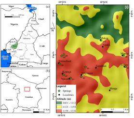
Figure 1. Location of the study zone: (a) West Region of Cameroon with their bordering countries; (b) Foumban in the Noun division of the West region; (c) studied zone.
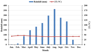
Figure 2. Ombrothermal diagram of the Foumban city, based on the mean monthly variations of rainfall and air temperature for the period of 2004 to 2019.
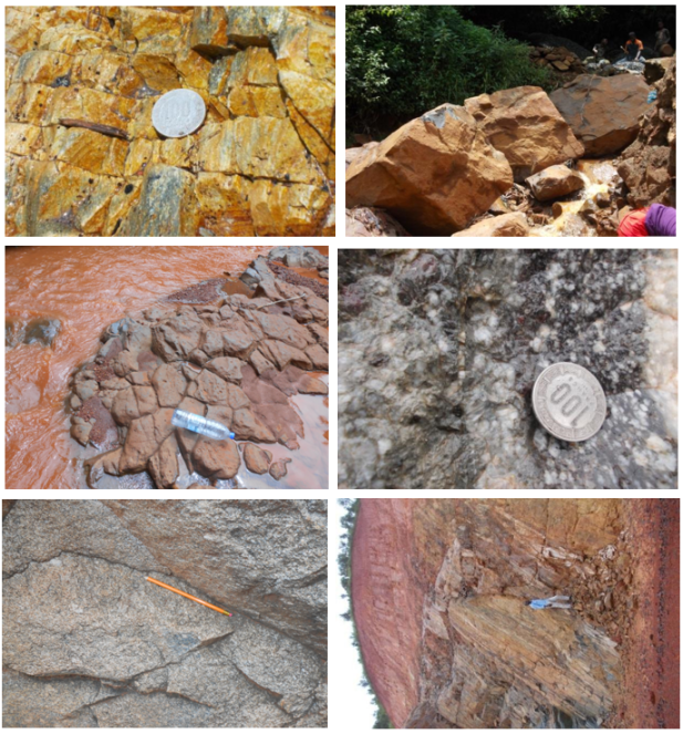
Figure 3. Some geological formations in the study area: a, b, c= magmatic rock; d, e, f= metamorphic rocks.
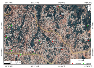
Figure 4. Google image of the urbanized zone of the Foumban locality illustrating ten (10) springs.
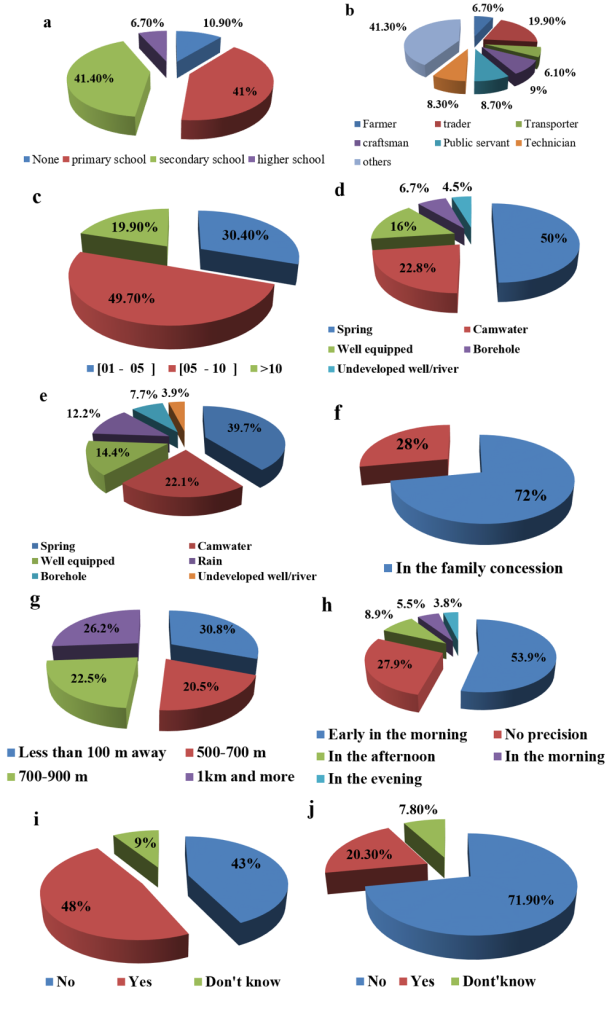
Figure 5. (a) Statistic data relating to the instruction level of the parents in the households; (b Statistic data relating to the parent economic activities; (c) Statistic data relating to the households size; (d) Distribution of the households surveyed in% according to the main source of drinking water supply in the dry season; (e); Distribution of the households surveyed in% according to the main source of drinking water supply in the rainy season; (f) Statistical data on water supply locations within households; (g) Statistical data on the distance between the concession and the nearest water supply point; (h) Statistical data relating to the best moments for the supply of drinking water to households (i) statistical data on the question relating to the need for treatment of water intended for drinking; (j) statistical data relating to paramount necessity to treat water before consumption.
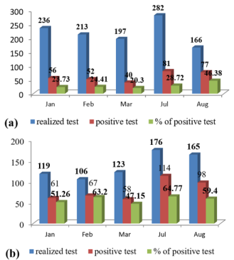
Figure 6. Water-related pathology statistics test at Foumban district hospital (a) malaria; (b) typhoid.
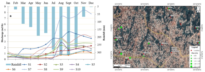
Figure 7. (a) Temporal (a) and spatial (b) variations of spring discharge in the study area.
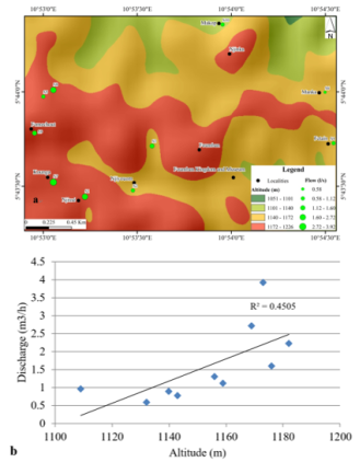
Figure 8. (a) Map presenting the relation between topography and spring discharge (b) correlation curve between topography and spring discharge.
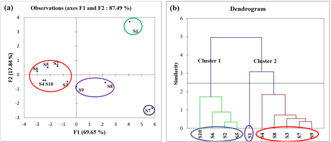
Figure 9. (a) Principal Component Analysis (PCA) for sampling points (b) Dendrogram of Hierarchical Cluster Analysis, based on monitoring sites.
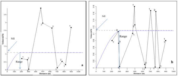
Figure 10. Semi-Variograms model obtained from spring discharge data in the Foumban (a) mean annual data (b) data of November month.
Information