1. Introduction
1.1. The Problem of the Study
"There is a relationship between natural space, land transport routes, and public transport paths, characterized by either continuity or discontinuity. Continuity in the first and discontinuity in the second reflects shortcomings in road planning. Similarly, continuity in the second, resulting from the continuity of the first, while the third lacks this characteristic, reflects shortcomings in public transport planning. The first possesses natural space, while the second and third together possess a topological structure. Continuity is the most important characteristic of this structure. "Unlike a topological space, natural space is not an abstract, continuous, renewable, flat, and symmetrical in all directions. It influences transportation networks through topography, climate, hydrography, and vegetation cover"
| [1] | Merlin, Pierre. Human Geography. French university presses, Paris. 2000, 579 P. |
[1]
. In other words: "roughness also results in isolation, which stems from weak connections with the outside world, and isolation is a condition of areas that suffer from weak communication and difficulty in accessing them"
| [2] | Bavoux, Jean-Jacques et al. Introduction à l'analyse spatiale. Armand Colin, Paris. 1998, 96 P. |
[2]
.
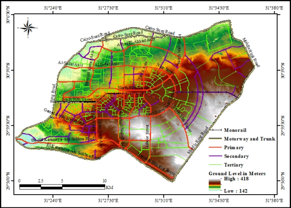
New Cairo did not experience any topographical obstacles that would impede the continuity of its area, as is evident from the 3D map in
Figure 1. It was originally established according to a prior plan of physical communication routes in order to develop a new desert part of Egypt and facilitate traffic movement between it and the old inhabited area. So, did the physical communication networks succeed in developing this part of the Egyptian desert, i.e., do the routes enjoy continuity in response to the continuity of the area served? Did the public transportation paths fully utilize the physical communication network, i.e., were they consistent with its continuity or interruption?
1.2. The Importance of the Study
Maintaining or even improving public transportation is a crucial element of social justice policy. Public transportation in New Cairo is divided into two categories: formal and informal. Formal transportation consists of official paths designed by government entities, which provide the necessary infrastructure, including stations, stops, and vehicles. Informal transportation, on the other hand, comprises vehicles licensed by government authorities to transport individuals between two points or within a specific neighborhood or city. Undoubtedly, the second type supports the first. The foundation of public transportation in any area rests on its formal form. The current research discusses formal transportation, which is tasked with encouraging settlement in areas further from the old inhabited zone and facilitating movement between the new and old inhabited zones, as well as movement within the new inhabited zone itself.
1.3. Study Area
New Cairo is located at the intersection of longitude 31°29'45"E and latitude 30°1'21"N. It lies east of the old inhabited area of Cairo. Its boundaries are defined by the four regional roads that border it: The Cairo-Suez Road to the north, El-Katameya-Ain Sokhna Road to the south, the Ring Road to the west, and the Middle Ring Road to the east (
Figure 1). According to this definition, New Cairo comprises several major residential areas and districts, such as Fifth Settlement, First Settlement, Third Settlement, and Rehab, in addition to numerous smaller neighborhoods and districts, including the Southern and Northern Investors District, Al-Narges District, and Al-Banafseg District. It also includes commercial areas like Cairo Festival City, as well as green spaces and sports facilities
(). New Cairo is characterized by its spatial continuity. Its land level gradually increases from west to east, ranging between 142 and 418 meters above sea level (
Figure 1). This has facilitated the construction of roads, bridges, and tunnels, and has also contributed to a moderate climate.
1.4. Objective of the Study
This research aims to identify available land transportation routes for use as public transportation paths, reflecting the role of these routes in urban development and establishing geography as a crucial element in public transportation planning (1). Furthermore, the research seeks to analyze the distribution of formal public transportation stations and its paths to assess the role of formal public transportation in the urbanization of this newly developed part of Egypt (2).
1.5. Data Sources and Methodology
The first question and the primary objective of the study can be answered by identifying, classifying, and distributing land transportation routes, finally, calculate its density. Geographic Information Systems (GIS), through its spatial analysis methodology, provided the essential foundation for answering this question and achieving the primary objective of the study through the following steps:
1) Support for GIS began by providing data, namely roads, through one of the open digital data platform: http://extract.bbbike.org
| [3] | Wolfram Schneider. BBBike.org - Map data (©) contributors. 2011-2025 / Shuttle Radar Topography Mission (SRTM), by NASA. |
[3]
, which was the sole source of land transportation routes data, as well as the open digital data platform http://www.opentopography.org/
| [4] | OpenTopography Facility, San Diego Supercomputer Center, University of California San Diego, 9500 Gilman Drive, La Jolla, CA 92093-0505 Copyright ©. |
[4]
to obtain the digital elevation model.
2) Then, a geographic information system (Arc-GIS 10.8) was used to extract only the cartographic and quantitative digital data pertaining to the study area, and to present it again in
Figures 1-3 and
Tables 1 and 2.
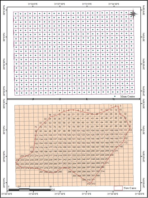
3) For a specific spatial distribution, G. I. S. have enabled the reduction of land transportation routes distribution to a count of cells within a spatial network. This is achieved by implementing a proposal to divide the study area into identical cells, each no larger than one square kilometer (500 cells), as shown in
Figure 4. This is done through {ArcToolBox - Data Management tools - Sampling - Create fishnet}. The system generates two layers: an area layer consisting of 500 cells and a point layer containing 500 points. New Cairo is covered by 314 cells, accompanied by the same number of points.
4) Then calculate what pertains to each spatial unit (314 cells) of the different lengths of roads belonging to each cell (Geoprocessing - Clip) first, calculate its density for each cell separately (Field Calculator) second, and digitize the result - road density - for each point belonging to each cell to prepare a road density map third, through spatial analysis tools {Arc-ToolBox - Spatial Analyst tools - Interpolation - an inverse distance weighted (IDW)} in the Arc-GIS10.8 system (
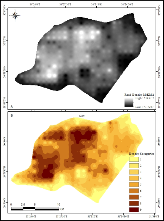
Figure 5A).
5) Finally, the New Cairo road traffic density map, as a raster layer, is converted to a vector after classifying the density into nine categories. The area of each category is then calculated using the following path: {Arc-ToolBox - 3D Analyst tools - Raster Reclass - Reclassify}. The resulting output appears as shown in
Figure 5B. The final output is then converted from raster to vector using the following path: {Arc-ToolBox - Conversion tools - From raster - Raster polygon}. An area report can then be generated using the (Summarize) function, based on the density categories (grid code), within the Arc-Map application interface.
The second question and the second objective of the study as is the case in many transport geography studies
can also be answered by relying on the field methodology implemented in the summer of 2025. This methodology involved identifying and classifying formal public transportation stations as organized or unorganized, determining the number of lines served by each station, and outlining their distribution points and paths from these stations to their exit from New Cairo. Through fieldwork, 10 formal public transport stations were identified, serving 107 public transport bus and minibus paths, connecting New Cairo with 44 stations in Cairo, Giza and Shubra El-Kheima.
Additionally, Google Maps was used to identify paths that the fieldwork could not reach. Geographic Information Systems (GIS) then played a role by employing spatial analysis using ArcGIS 10.8 to create and manage a spatial database of formal public transportation stations and their paths, and to design the study maps. Furthermore, analysis was performed using (Analysis Tools) and (Spatial Statistics Tools), specifically the following:
1) The scope of allocation for formal public transport stations is as follows: {ArcToolbox - Analysis tools - Proximity - Create Thiessen Polygons}.
2) The mean center for formal public transport stations and the New Cairo area via the following route: {ArcToolbox - Spatial Statistics Tools - Measuring Geographic Distributions - Mean Center}.
3) The weighted mean center for formal public transport stations via the following route: {ArcToolbox - Spatial Statistics Tools - Measuring Geographic Distributions - Mean Center}.
4) The standard distance for formal public transport stations via the following route: {ArcToolbox - Spatial Statistics Tools - Measuring Geographic Distributions - Standard Distance}.
5) The nearest neighbor factor to formal public transport stations via the following route: {ArcToolbox - Spatial Statistics Tools - Analyzing Patterns - Average Nearest Neighbor}.
6) Cut the land transport routes in each of the cells covering New Cairo (314 cells) using the following route: {ArcToolbox - Analysis tools - Extract - Clip}.
7) Merge all formal public transport paths in New Cairo into one path using the following route: {ArcToolbox - Data Management Tools - General - Merge}.
8) Draw a 400-meter radius around the formal public transport paths using the following route: {ArcToolbox - Analysis tools - Proximity - Buffer}.
9) Integrating two layers: a 400-meter range around formal public transport paths + the New Cairo area: {ArcToolbox - Analysis tools - Overlay - Union}.
1.6. Previous Studies
Undoubtedly, all transport geography studies in the Egyptian school, which amounted to 555 studies up to 2020
| [7] | Badir El Sayed, Shaaban Youssef, Ibrahim, Mohamed Sobhi. Transportation Geographical Studies in the Arab Geographical Journal during (1968-2020): Presentation and Analysis. Egyptian Geographical Society, Arab Geographical Journal. 2022, 53(80), 57-88.
https://agj.journals.ekb.eg/article_271643.html |
[7]
without exception, have addressed the topics of the current study. However, the difference between them lies in their reliance on Geographic Information Systems (GIS) and its spatial analysis methodology, as well as their contemporary treatment of public transport routes, stations, and paths in New Cairo. Nevertheless, the schools of thought from which the current study drew its approach to the subject matter were the study on Communications in the book (Géographie urbain) in 1997
| [8] | Beaujeu-Garnier, Jacqueline. Urban Geography. Armand Colin, Paris. 1997, fifth edition, 349 P. |
[8]
and the study on Transport Planning: An Example of (Structural aménagement) in the book (Géographie humaine) in 2000
| [1] | Merlin, Pierre. Human Geography. French university presses, Paris. 2000, 579 P. |
[1]
. The analysis itself was drawn from the distinguished book: (L'analyse spatiale dans l'espace: 1. Localisation dans l'espace)
| [9] | Pumain Denise, Saint-Julien Thérèse. Spatial Analysis in Space: 1. Spatial Location. Cursus Collection, "Geography" series, edited by Ph. Pinchemel, Armand Colin & Masson, Paris. 1998, 168 P. |
[9]
, and the book: (Introduction à l'analyse spatiale) also played a role in the spatial analysis of the current study (1998)
| [2] | Bavoux, Jean-Jacques et al. Introduction à l'analyse spatiale. Armand Colin, Paris. 1998, 96 P. |
[2]
.
The study of Obour City focused on urban transport in another new city in Egypt, but it did not address the topic through Geographic Information Systems, as it focused on using the historical and fundamental methods
| [10] | Abu Al-Nasr, Magdi Sayed Ahmed. Al-Obour City: A Study in Urban Transport Geography. Middle East Research Journal, Ain Shams University, Middle East Research Center. 2013, 32, 375-468. |
[10]
; therefore, it is considered one of the important studies in the current research.
The current study also benefited from the various concepts presented in a study, "Passenger Transport by Taxis in Menoufia Governorate and its Role in Achieving Spatial Integration (2020)," such as spatial integration, interactivity, and spatial diffusion. It also drew upon methods for analyzing the geographical distribution of the paved road network, the geographical distribution of taxis, and the geographical distribution of passenger transport routes
| [11] | Shawish, Adel Mohamed. Passenger Transport by Taxis in Menoufia Governorate and its Role in Achieving Spatial Integration. Journal of Research of the Faculty of Arts, Menoufia University. 2020, 31(122), 3-25.
https://sjam.journals.ekb.eg/article_158710.html |
[11]
.
The study entitled: Public Transport Stations in Cairo Governorate “An Applied Geographical Study on the Central Region” is one of the previous studies on public transport stations. The current study benefited from it in terms of how to distribute and pattern, as well as the detailed study of the stations: Ahmed Helmy, Abdel Moneim Riad, Ataba
| [12] | Noor El-Din, Mona Sobhi El-Sayed. Public Transport Stations in Cairo Governorate: An Applied Geographical Study on the Central Region. Egyptian Geographical Society, Geographical Research Series. 2018, 121. |
[12]
.
The study entitled: Integrating the religious function, tourist accommodation and transportation in the Saudi Vision for Sustainable Development 2030, presents how to address the issue of roads within multiple topics under the umbrella of sustainable development
| [13] | Salama, Atef Hafez. Integrating the religious function, tourist accommodation and transportation in the Saudi Vision for Sustainable Development 2030. Journal of the Egyptian Scientific Society in Cairo. 2023, 98, 185-224.
https://jfnile.journals.ekb.eg/article_223035.html |
[13]
.
The study entitled: Sustainable Development of Land Transport Routes in Menoufia Governorate Using Geographic Information Systems, presents a road treatment methodology through Geographic Information Systems by examining the relationship between population size and road size in Menoufia Governorate
| [14] | Salama, Atef Hafez. Sustainable Development of Land Transport Routes in Menoufia Governorate Using Geographic Information Systems. Journal of the Egyptian Scientific Society in Cairo. 2025, 100, 145-169.
https://jfnile.journals.ekb.eg/article_350645.html |
[14]
.
The two questions posed, the study’s objectives, and the benefits of previous studies can be achieved by discussing three consecutive research points: land transport routes, formal public transport stations, and finally, formal public transport paths.
2. Land Transport Routes in New Cairo
"Just as the human body is held in place by its skeleton and sustained by the blood that flows through its veins, so too are urban organizations organized on a network of communication routes and means of transport through which they move. Communication roads are divided into two main categories: physical communication facilitating the movement of people or tools, which are always present and have created distinct, particularly developmental, features within the urban space; and connectivity that allows the transmission of messages in various forms but without the need for human movement. Both types have significant implications for urban life and urban planning"
| [8] | Beaujeu-Garnier, Jacqueline. Urban Geography. Armand Colin, Paris. 1997, fifth edition, 349 P. |
[8]
. The role of physical communications in the urbanization of New Cairo can be discussed through: the dimensions and patterns of land transport routes, and their density.
2.1. Dimensions and Patterns of Land Transport Routes
"During the period from 2014 to 2021, Egypt underwent a revolution of development and modernization in the transport sector through an unprecedented qualitative and quantitative shift in the transport sector to double the inhabited area at the expense of the deserted area and to advance the comprehensive and sustainable development process"
.
Table 1. Road Patterns in New Cairo City 2025.
Number | Type | Length (M) | % |
1 | Construction | 475539 | 8.35 |
2 | Footway | 1018872 | 17.90 |
3 | Motorway | 56274 | 0.99 |
4 | Motorway link | 11460 | 0.20 |
5 | Path | 8450 | 0.15 |
6 | Pedestrian | 2842 | 0.05 |
7 | Platform | 562 | 0.01 |
8 | Primary | 295607 | 5.19 |
9 | Primary link | 22759 | 0.40 |
10 | Raceway | 1496 | 0.03 |
11 | Residential | 2014850 | 35.39 |
12 | Secondary | 184469 | 3.24 |
13 | Secondary link | 9588 | 0.17 |
14 | Service | 517889 | 9.10 |
15 | Steps | 2450 | 0.04 |
16 | Tertiary | 785136 | 13.79 |
17 | Tertiary link | 23110 | 0.41 |
18 | Track | 2764 | 0.05 |
19 | Trunk | 77519 | 1.36 |
20 | Trunk link | 26569 | 0.47 |
21 | Unclassified | 121074 | 2.13 |
22 | Monorail | 33491 | 0.59 |
Total | 5692772 | 100.00 |
Source: Table Compiled by the Researcher Using the Open Data Platform: http://extract.bbbike.org
| [3] | Wolfram Schneider. BBBike.org - Map data (©) contributors. 2011-2025 / Shuttle Radar Topography Mission (SRTM), by NASA. |
[3]
The total length of roads in New Cairo is 5,693 km, covering an area of 264 km
2. This high total road length relative to the limited area is due to the variety of road types. New Cairo has 21 different types of paved roads in addition to the Monorail (
Table 1). Residential Streets constitute the longest road type, accounting for 35.39% of the total road length in New Cairo. This is followed by footway, which represent 17.90%. This indicates that residential streets and footways together make up more than half of the roads in New Cairo.
The Motorway and Trunk Road contribute to the road network of New Cairo through five major routes. These include four regional roads connecting Cairo and New Cairo to other regions in Egypt, such as the Delta, the Nile Valley, and the Suez Canal. These roads include the Cairo-Suez Road - towards Suez, which borders New Cairo to the north; El-Katameya-Ain Sokhna Road - towards Cairo, which borders it to the south; and the Middle Ring Road - towards the south, which borders it to the east and connects the Suez and Ain Sokhna roads. They also include the Ring Road around Greater Cairo - towards the north, which borders New Cairo to the west. Additionally, they include a section of South 90th Street, which cuts through New Cairo from the west, extending for approximately 4 kilometers. These roads have numerous Motorway links and Trunk links, facilitating easy access to and from New Cairo, as well as traffic flow between the two directions (
Figure 1).
New Cairo also possess Primary roads, which are major highways designed for through traffic, connecting towns, cities, and large areas. These roads are an essential part of the national road network, providing optimal paths for heavy traffic. Although slower than Motorway and Trunk Road, they are a vital link in the transportation system. This pattern is exemplified by several axes, such as Youssef El-Sebai Axis, Mustafa Kamel Axis, part of Mohamed Naguib Axis, Taha Hussein Axis, Talaat Harb Axis, part of Gamal Abdel Nasser Axis, East Nasser Axis, Al-Orouba Axis, Al-Sadat Axis, the American University Axis, and Tahrir Axis, as well as numerous streets, including Nasr Street, Obour Street, North 90th Street, the remainder of South 90th Street, National Housing Street, and many others. Several Primary links serve this road pattern (
Figure 1).
Figure 1. Monorail, Motorway, Trunk, Primary, Secondary and Tertiary Road in New Cairo 2025.
Source: The Map Compiled by the Researcher Using the Open Data Platform: http://extract.bbbike.org
| [3] | Wolfram Schneider. BBBike.org - Map data (©) contributors. 2011-2025 / Shuttle Radar Topography Mission (SRTM), by NASA. |
[3]
and http://www.opentopography.org/
| [4] | OpenTopography Facility, San Diego Supercomputer Center, University of California San Diego, 9500 Gilman Drive, La Jolla, CA 92093-0505 Copyright ©. |
[4]
The previous pattern connects to Secondary roads, which are less important than the main road, but remain connected to the main road network. It can serve as an alternative to main roads, alleviate congestion on main roads, or provide access to smaller streets and specific areas, such as residential streets. This road pattern is evident in several axes and streets, such as Naguib Mahfouz Axis, part of Mohamed Naguib Axis, Mohamed Farid Axis, Abbas El-Akkad Axis, Shenzhou Abi Axis, Saad Zaghloul Axis, part of Gamal Abdel Nasser Axis, Ahmed Shawqi Axis, Axis 82, and Axis 79. It also applies to Qasim Amin Street, Omar Ibn Abdel Aziz Street, Ali Ibn Abi Talib Street, Abdullah Ibn Salma Street, Salah El-Din Abdel Karim Street, Zizinia Street, Engineer Hassan Fathy Street, Al-Moshir Ahmed Ismail Street, El-Shweifat Street, El-Shabab Street, the North 90th Street side street, and Abu Bakr El- Siddiq Street. Numerous Secondary links serve this road pattern in New Cairo (
Figure 1).
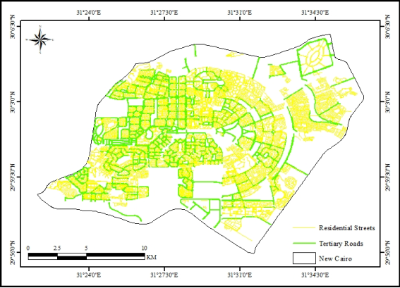
Branching off from the previous pattern are Tertiary Roads, which are local roads connecting smaller settlements such as villages, or serving as local collection routes within a larger urban area. These roads are characterized by low to moderate traffic volume and are often less important than main or secondary roads, providing access to local centers and residences. This type of road is more widespread than the previous type and those before it. It is exemplified by the side roads of various axes, as well as by many roads such as Al-Futtaim, Al-Mahajir, El-Katameya, and Al-Bunuk, and numerous streets such as Yousry Amara, Wassef Ghali Pasha, Mivida, Musab Ibn Umair, Mustafa Sadiq Al-Rifai, Mustafa Amin, Masaken Al-Nil, Masaken Al-Giza, Mahmoud Seddik, Mahmoud Sharif, and others. Many Tertiary links also serve this type of road (
Figures 1 and 2).
Figure 2. Residential Streets and Tertiary Roads in New Cairo 2025.
The latter gives off the Residential Streets, which are the longest and most widespread of all types of roads, because they serve the housing that represents the basic function of New Cairo (
Figure 2).
New Cairo also has other types of roads that, along with the previous types, complete the network coverage for the entire area. This is also the case with the East Nile Monorail line, which runs from Cairo International Stadium to the New Capital, passing through New Cairo (
Figure 1). It is worth noting that physical communications to New Cairo are not limited to surface roads, but also include above-ground and underground roads.
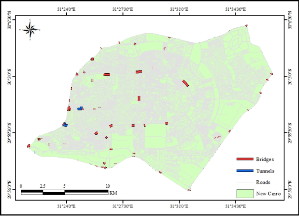
New Cairo has three tunnels: two are terminal and the third is within the city. To facilitate movement between the Ring Road - Maadi direction and New Cairo, the oldest tunnel in New Cairo, the New Cairo Tunnel, was built at the intersection of Gamal Abdel Nasser Axis with the Ring Road, to serve as an exit for those heading to Maadi and southern Cairo and an entrance for those coming from the north via the Ring Road to New Cairo. The Major General Zaki Baqi Youssef Tunnel is the only tunnel within New Cairo. This internal tunnel connects two of the most important roads in New Cairo: North 90th Street and South 90th Street. This facilitates traffic flow between them and provides a good link between the First and Fifth Settlements. The final tunnel is a terminal tunnel connecting New Cairo on one side with El-Katameya-Ain Sokhna Road on the other. Al-Moshir Ahmed Ismail Tunnel connects the old Katameya-Ain Sokhna Road, which now runs through New Cairo, with the New Katameya-Ain Sokhna Road - towards Ain Sokhna (
Figure 3).
The large number of bridges explains the small number of tunnels in New Cairo. The Mohamed Naguib Axis is one of the most important roads that benefited from the construction of bridges to facilitate traffic flow along its length. The Mohamed Naguib Axis stretches from the far north of the city to its far south. Therefore, at its intersection with North and South 90th Streets, it passes over them with one of the most important bridges - the Mohamed Naguib Bridge - which is influential in solving the traffic crisis in the heart of New Cairo. The same axis also features two bridges spanning the old Katameya-Ain Sokhna Road and the new Katameya-Ain Sokhna Road. Furthermore, it includes the only bridge over the Cairo-Suez Road (Cairo-bound), facilitating connections between New Cairo, Heliopolis, Cairo Airport, and North Cairo. These bridges allow vehicles to travel uninterrupted from the far north to the far south of the city, making the Mohamed Naguib Axis the easiest link between the Cairo-Suez and El-Katameya-Ain Sokhna Roads (
Figure 3).
Although Talaat Harb Axis is shorter than Mohamed Naguib Axis, it boasts three bridges. The first crosses at its intersection with the old Katameya-Ain Sokhna Road, the second at its intersection with Al-Mahajir Road, and the last at its intersection with the new Katameya-Ain Sokhna Road.
Figure 3. Bridges and Tunnels in New Cairo 2025.
Samir Ghanem Bridge comes on the Shenzhou Abe Axis, which is an extension of the Naguib Mahfouz Axis, to represent another new link that bypassed the Ring Road crisis to cross it to the other side and facilitate good communication between New Cairo and Nasr City.
Al-Futtaim Bridge is one of the links that handles the intersection of perpendicular roads, such as Al-Sadat Axis on the Ring Road. Al-Futtaim Bridge facilitates easy traffic flow between New Cairo and Zahraa Madinet Nasr.
Al-Batalah Ferial Abdel Aziz Bridge is a new link connecting New Cairo and Nasr City. This bridge connects Taha Hussein Axis in New Cairo with Al-Moshir Mohamed Ali Fahmy Axis in Nasr City.
Al-Moshir Tantawi Bridge is the fourth such bridge, after Al-Batalah Ferial Abdel Aziz Bridge, to overcome the problem of the intersection of two perpendicular roads: South 90th Street and the Ring Road. Al-Moshir Tantawi Bridge crosses the Ring Road, connecting South 90th Street with Al-Moshir Tantawi Axis, where the Air Defense Stadium, the new exhibition grounds, and the new urban expansions east of Cairo are located (
Figure 3).
Major General Omar Suleiman Bridge is one of the newest bridges overcoming the obstacle of the Ring Road. This bridge is located at the end of the Gamal Abdel Nasser Axis, connecting the Dr. Samira Moussa Axis with New Cairo. It is worth noting that this location previously featured one of the tunnels constructed to connect the Ring Road - Maadi direction - with the Gamal Abdel Nasser Axis in New Cairo. This indicates that this point in New Cairo has three levels of roads: the surface level represented by the exit of the Gamal Abdel Nasser Axis to the Ring Road in the north direction, the subsurface level represented by the New Cairo Tunnel to the Ring Road in the south direction, and the overhead level represented by Major General Omar Suleiman Bridge linking the Gamal Abdel Nasser Axis and Dr. Samira Moussa Axis.
This means that New Cairo overcomes the artificial boundary of the Ring Road with five bridges: Samir Ghanem, Al-Futtaim, Al-Batalah Ferial Abdel Aziz, Al-Moshir Tantawi, and Major General Omar Suleiman. In addition, there is the Suez Bridge on the same Ring Road to allow free movement of vehicles on the Cairo-Suez Road. There is also the Mohamed Fawzy Bridge, which allows El-Katameya-Ain Sokhna Road to bypass its intersection with the Ring Road and connects El-Katameya-Ain Sokhna Road in New Cairo with the Martyr's Axis on the other side of the Ring Road (
Figure 3).
On the Cairo-Suez Road, there are several bridges that facilitate traffic flow between the two directions. These include the Ahmed Badawi East Bridge, which carries traffic from Suez towards Cairo, and the Ahmed Badawi West Bridge, which carries traffic from Cairo towards Suez.
There is a bridge on Cairo-Suez Road, which forms part of the Cairo-Suez Road itself. This bridge allows vehicles to pass underneath, connecting New Cairo with the new public transport station north of the Cairo-Suez Road - towards Cairo.
The Middle Ring Road passes over the Cairo-Suez Road to the north and over El-Katameya-Ain Sokhna Road to the south via two bridges that allow vehicles to continue moving over and under them easily and smoothly.
Gamal Abdel Nasser Axis runs east-west, which has led to traffic congestion at its intersections with north-south axis and streets. Therefore, many of these intersections have been converted into overpasses to allow for continuous traffic flow along Gamal Abdel Nasser Axis from the far east of the city to its exit onto the Greater Cairo Ring Road. Six bridges extend along the Gamal Abdel Nasser Axis. The first, on the western side, is the Major General Omar Suleiman Bridge, which crosses the Ring Road to connect Dr. Samira Moussa Axis with New Cairo, as previously mentioned. The second bridge is located at Arbella Square, allowing passage bypassing this square. The third bridge spans the north-south Talaat Harb Axis. The fourth bridge crosses Al-Nahda Square, a major intersection where the two axes, Mohamed Naguib and Gamal Abdel Nasser, meet. The fifth bridge also crosses the intersection of Gamal Abdel Nasser Axis with Al-Gezira Street. Finally, the sixth bridge crosses the intersection of Gamal Abdel Nasser Axis with the American University Axis (
Figure 3).
Al-Sadat Axis runs east-west, starting from the Al-Futtaim Bridge, which crosses the Ring Road and connects New Cairo and Nasr City - Al-Mithaq Street. It then extends eastward, crossing its intersection with the Mustafa Kamel Axis via the second bridge. It continues eastward, crossing its intersection with the Mohamed Naguib Axis via the third bridge. This means that Al-Sadat Axis has three bridges that facilitate smooth traffic flow along its east-west length (
Figure 3).
Al-Nasr Street, which appears in the form of an arc connecting Al-Sadat Axis in the First Settlement and Gamal Abdel Nasser Axis in the Fifth Settlement, goes beyond its intersection with North 90th Street through a bridge that facilitates movement between the two axes. There is also a bridge on Al-Mahajir Road above El-Katameya-Ain Sokhna Road, which facilitates crossing the latter.
Bridges in New Cairo are not limited to vehicles; they also include numerous pedestrian bridges, used for crossing roads, such as the pedestrian bridges over 90th Street, and for crossing artificial ponds and wadi beds in New Cairo's parks. There are 48 pedestrian bridges of this type.
All of this reflects the diversity and large size of road lengths in New Cairo, but the pattern and length alone are not enough to conclude the extent of network coverage for all parts of New Cairo; therefore, road density can be relied upon by measuring the relationship between road length and area.
2.2. Road Density
"It is essential to describe the network in relation to the areas it covers or serves. The simplest measure is density, which relates the total length of the network to the area it covers"
| [9] | Pumain Denise, Saint-Julien Thérèse. Spatial Analysis in Space: 1. Spatial Location. Cursus Collection, "Geography" series, edited by Ph. Pinchemel, Armand Colin & Masson, Paris. 1998, 168 P. |
[9]
. The overall average road density in New Cairo is 21.56 km/km
2. However, this average does not reflect the complete coverage of New Cairo by the road network. Therefore, density must be measured on a smaller scale.
Relying on residential neighborhoods as a unit of area as in many studies
| [5] | Badir El Sayed, Shaaban Youssef. Internal Transport in the City of Bella. Journal of the Egyptian Scientific Society in Cairo. 2025, 100, 171-210.
https://jfnile.journals.ekb.eg/article_426192.html |
| [6] | Abu Yazid, Jihan Mohammed. Efficiency and Geographical Reach of the Tram Network in Alexandria: A Study in Urban Geography. Egyptian Geographical Society, Arab Geographical Journal. 2020, 75, 121-178.
https://agj.journals.ekb.eg/article_107597.html |
| [7] | Badir El Sayed, Shaaban Youssef, Ibrahim, Mohamed Sobhi. Transportation Geographical Studies in the Arab Geographical Journal during (1968-2020): Presentation and Analysis. Egyptian Geographical Society, Arab Geographical Journal. 2022, 53(80), 57-88.
https://agj.journals.ekb.eg/article_271643.html |
| [8] | Beaujeu-Garnier, Jacqueline. Urban Geography. Armand Colin, Paris. 1997, fifth edition, 349 P. |
| [9] | Pumain Denise, Saint-Julien Thérèse. Spatial Analysis in Space: 1. Spatial Location. Cursus Collection, "Geography" series, edited by Ph. Pinchemel, Armand Colin & Masson, Paris. 1998, 168 P. |
| [10] | Abu Al-Nasr, Magdi Sayed Ahmed. Al-Obour City: A Study in Urban Transport Geography. Middle East Research Journal, Ain Shams University, Middle East Research Center. 2013, 32, 375-468. |
| [11] | Shawish, Adel Mohamed. Passenger Transport by Taxis in Menoufia Governorate and its Role in Achieving Spatial Integration. Journal of Research of the Faculty of Arts, Menoufia University. 2020, 31(122), 3-25.
https://sjam.journals.ekb.eg/article_158710.html |
| [12] | Noor El-Din, Mona Sobhi El-Sayed. Public Transport Stations in Cairo Governorate: An Applied Geographical Study on the Central Region. Egyptian Geographical Society, Geographical Research Series. 2018, 121. |
| [13] | Salama, Atef Hafez. Integrating the religious function, tourist accommodation and transportation in the Saudi Vision for Sustainable Development 2030. Journal of the Egyptian Scientific Society in Cairo. 2023, 98, 185-224.
https://jfnile.journals.ekb.eg/article_223035.html |
| [14] | Salama, Atef Hafez. Sustainable Development of Land Transport Routes in Menoufia Governorate Using Geographic Information Systems. Journal of the Egyptian Scientific Society in Cairo. 2025, 100, 145-169.
https://jfnile.journals.ekb.eg/article_350645.html |
[5-14]
may not be helpful in this regard due to the varying distribution of roads within a single neighborhood, especially if it is large. Roads and streets are often used to define the boundaries of different neighborhoods, making it difficult to determine whether a particular road or street belongs to one neighborhood or another. Therefore, a division can be proposed to help reveal the actual distribution of the road network in New Cairo.
The area under study is a surface; therefore, it is inherently continuous. Applying a grid to this surface means dividing it into smaller areas, corresponding to the number of grid cells. The statistical advantage of a regular grid lies in its neutrality, unlike, for example, an administrative grid, whose shape has often been fixed for a long time and is associated with a specific function. A regular grid also avoids all biases resulting from inequalities in the shape and size of its cells
| [9] | Pumain Denise, Saint-Julien Thérèse. Spatial Analysis in Space: 1. Spatial Location. Cursus Collection, "Geography" series, edited by Ph. Pinchemel, Armand Colin & Masson, Paris. 1998, 168 P. |
[9]
. The study is based on dividing New Cairo into cells (
Figure 4). Each cell is no larger than one square kilometer. A cell of this size is smaller than any neighborhood in New Cairo. New Cairo is comprised of 314 cells, with 5,693 km of roads and streets running through 313 of them, meaning that no more than one cell has completely vacant roads. This reflects the comprehensive coverage of the road and street network throughout New Cairo.
After separating the roads and streets within each cell, it became easy to calculate the road density for each cell. All cells have the same area but differ in road lengths, and therefore, their density varies significantly. The result of this quantitative calculation is assigned to points that are numbered as the spatial average for each cell. This allows for the creation of a road density map using the Spatial Analyst tools in ArcGIS 10.8. The system generates a raster density map, which is then converted to a vector to allow for the extraction of the area for each density category (
Table 2).
Figure 4. Dividing New Cairo into Identical Cells and the Mean Center.
Road density ranges from over 51 km/km
2 to as low as 0.03 km/km
2, and certainly never exceeds zero by more than a single cell. This significant variation has led to the division of New Cairo into nine categories based on road density (
Table 2).
Road density gradually decreases from its peak within New Cairo to its base at the outskirts (
Figure 5). The highest road density in New Cairo is at 4.1% of its total area, concentrated in eight distinct zones. These zones are located in the neighborhoods of Rehab, Arbella, part of the Youth Housing in the First Settlement, Al-Futtaim, the American University in Cairo, Durrat Al-Karaz Compound, and part of the Youth Housing in El-Katameya. The areas surrounding the aforementioned zones are less dense, occupying a larger area of 10.95%. These zones, in turn, are surrounded by even less dense zones and comprise 10.4% of the total area of New Cairo. The sixth zone occupies the largest area, having managed to encircle the more densely populated zones, reaching 13.5%. Following this are the areas of the fifth zone, which approach the northern and southern edges of New Cairo, occupying 16% of the total area of New Cairo. Then come the areas occupying the fourth, third, second, and finally the first categories, which appear as limited bands surrounding the previous categories, particularly to the north and south. To the east, these bands widen until they reach the central ring road (
Figure 5).
Figure 5. Road Density in New Cairo 2025.
It is worth noting that the areas located on the outskirts of New Cairo from all sides appear to have the least density of roads due to two main reasons: one of them is the exclusion of the other direction from the roads: Suez, El-Katameya, Middle Ring Road and Ring Road, and the second is that the cell boundaries do not stop at the borders of New Cairo but extend beyond them, and therefore the share of each cell passing through the outskirts of the study area has become limited in terms of road lengths.
Table 2. Land Distribution According to Road Density Categories in New Cairo 2025.
ID | Categories M/KM2 | Area M2 | Area KM2 | % |
From | To |
1 | 30 | 6836 | 24512987.6 | 24.5 | 9.28 |
2 | 6836 | 11111 | 24566613.0 | 24.6 | 9.30 |
3 | 11111 | 15250 | 28767390.5 | 28.8 | 10.89 |
4 | 15250 | 18881 | 40500150.6 | 40.5 | 15.33 |
5 | 18881 | 22634 | 42164492.8 | 42.2 | 15.96 |
6 | 22634 | 26769 | 36666946.9 | 36.7 | 13.88 |
7 | 26769 | 31008 | 27531250.7 | 27.5 | 10.42 |
8 | 31008 | 36832 | 28680172.6 | 28.7 | 10.86 |
9 | 36832 | 51458 | 10811363.4 | 10.8 | 4.09 |
Total | 264201367.9 | 264.2 | 100.00 |
Source: Table compiled by the researcher using the open data platform: http://extract.bbbike.org
| [3] | Wolfram Schneider. BBBike.org - Map data (©) contributors. 2011-2025 / Shuttle Radar Topography Mission (SRTM), by NASA. |
[3]
2.3. What Next
If roads reached the furthest point but public transportation couldn't reach it, urbanization would be deficient. An abundance of roads alone is insufficient for urbanization; they must also have, or be connected to, formal and informal public transportation paths capable of carrying large numbers of passengers. These paths must have stations to regulate the flow of formal public transportation in all directions. Do these roads have stations to regulate formal public transportation?
3. Formal Public Transport Stations
The study of bus station is one of the research areas in urban transport geography. It is an important study as it requires the necessity of studying the geographical distribution of international, regional, main local, and random station areas, studying deprived areas, finding some alternatives and proposals to cover all areas of the region, studying the services provided inside the station areas, studying the means of transport in them, the extent of their organization and planning to manage traffic flow and the absence of traffic disruption, whether they are equipped station areas with specific locations or whether they occupy part of the road on the sides or in the median of the road, whether they are in residential areas isolated from the road or are directly on the road, and they need geographical studies
| [12] | Noor El-Din, Mona Sobhi El-Sayed. Public Transport Stations in Cairo Governorate: An Applied Geographical Study on the Central Region. Egyptian Geographical Society, Geographical Research Series. 2018, 121. |
[12]
.
The relationship between formal public transport stations and the urbanization of New Cairo can be examined by analyzing their distribution. These stations serve as hubs where formal public transport originates and converges; wherever they are located, all formal public transport vehicles head towards and depart from them. Therefore, their proximity to the older, more populated areas hinders urbanization in areas further away, while their proximity to the furthest reaches facilitates urbanization. This point addresses two main issues: the distribution of formal public transport stations and the spatial analysis of this distribution.
3.1. Distribution of Formal Public Transport Stations
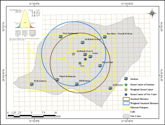
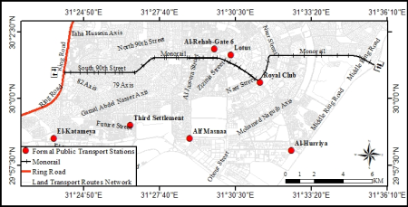
There are 10 formal public transport stations in New Cairo (
Figure 6), meaning they are distributed across only 10 out of 314 cells, or 3.14% of the total cells covered by New Cairo. These stations are as follows: First Settlement, Lotus, Al-Hurriya, El-Katameya, Third Settlement, Alf Masnaa, Dar Misr - Naayib El-Eam, Al-Rehab-Gate 6, and Royal Club.
The distribution of formal public transport stations in New Cairo reflects the presence of four in the southern sector, three in the northern sector, and three in the central sector. These stations cover an area of 264 km
2, averaging 26.4 km
2 per station. However, the area allocated to each station varies considerably, ranging from 9 km
2, as in the case of the Lotus station, to 35 km
2, as in the case of the First Settlement station, as illustrated in
Figure 6. This reflects the uneven distribution of these stations in New Cairo, a fact further demonstrated by the spatial statistical analysis to be discussed later.
3.2. Spatial Statistical Analysis of the Distribution of Formal Public Transport Stations
The mean center, weighted mean center, standard distance, weighted standard distance, and nearest neighbor coefficient are useful spatial statistical analysis tools for analyzing the distribution of formal public transport stations. The first describes the degree of correspondence between the spatial mean of the stations and that of New Cairo, the second describes the distribution of stations relative to their mean center, and the last determines, with a specific value, the degree of concentration, dispersion, or uniformity of the station distribution.
3.2.1. The Mean Center
The mean center of formal public transport stations in New Cairo is at the intersection of longitude 31°29'8" and latitude 30°0'54", while the mean center of New Cairo itself is at longitude 31°29'45" and latitude 30°1'21". This means that the mean center of the phenomenon under study—formal public transport stations—does not coincide with the center of the area under study; rather, the latter is 1291 meters away, as shown in
Figure 6. This indicates that the distribution of formal public transport stations did not take into account the expansion of New Cairo.
Undoubtedly, the number of bus and minibus lines served by each formal public transport station is a significant factor in determining its ranking. The number of lines served rises to 47 at the First Settlement station, while it drops to only 2 at Alf Masnaa station. Therefore, the weighted mean center offers a new location that is 2260 meters away from the mean center and 2355 meters away from its counterpart in New Cairo, as shown in
Figure 6. This confirms that the distribution of formal public transport stations does not take into account the dimensions of New Cairo. This is clearly demonstrated by measuring the standard distance.
3.2.2. Standard Distance
Despite the fact that the distribution of formal public transport stations does not take into account the dimensions of New Cairo, as evidenced by the mean center and weighted mean center indices, the measurement of the standard distance proves the dispersed distribution of these stations within the first standard circle. Only 60% of these stations are located within this circle, reflecting the distance of the formal public transport stations from the circle's center, i.e., the mean center, as illustrated in
Figure 6.
Figure 6. Application Some of Analysis Tools and Spatial Statistics Tools for Distribution of Formal Public Transport Stations in New Cairo 2025.
It is worth noting that the standard distance index allows for weighting these stations based on the number of lines served by each station. The weighted standard distance yields a different result than the previous one. 70% of formal public transport stations are concentrated within the first standard circle, weighted by the number of lines served by each station. This result aligns with the mean center or weighted mean center, both confirming that the distribution of formal public transport stations in New Cairo does not take into account the city's dimensions, and that 70% of them are concentrated within the first standard circle, as illustrated in
Figure 6. However, this tool does not provide a specific value for the degree of concentration of formal public transport stations in New Cairo.
3.2.3. Nearest Neighbor Coefficient
The nearest neighbor coefficient determines the distribution pattern of formal public transport stations in New Cairo. The nearest neighbor coefficient for the distribution of formal public transport stations in New Cairo is 1.27, confirming that their distribution is scattered but tends toward regularity, as shown in
Figure 6. The average observed distance is 3276.7 meters, the average expected distance is 2571.2 meters, the standard Z-score is 1.66, and the probability P-value is 0.097. Does the tendency toward regularity in the distribution of formal public transport stations reflect on the distribution of lines originating from or heading towards them?
4. Formal Public Transport Paths
Based on fieldwork conducted in 2025, the number of formal public transport paths in the ten stations of New Cairo reached 107, distributed unevenly among these stations. Therefore, the distribution of these formal public transport paths can be analyzed using two types of analysis: quantitative and spatial. Quantitative analysis examines the relationship between the lengths of roads suitable for formal public transportation and the corresponding lengths of these paths. It also presents the actual paths of each station to determine whether they complement or compete with each other in providing formal public transportation services in New Cairo. Spatial analysis, on the other hand, addresses the extent to which these paths cover the entirety of New Cairo and thus examines their role in its urbanization.
4.1. Quantitative Analysis of Formal Public Transport Paths
Roads are the engine of urban development. Roads of various types are available in New Cairo through 5693 km, however, the length of the 107 paths in both directions is 2695 km, in addition to 33.5 km for the Monorail within New Cairo only. If formal public transportation were limited to road types suitable for such modes of transport, the total length of transport routes would be 4058.7 km. This means that only 71.3% of the total length of suitable roads would be utilized. Consequently, 28.7% of the road lengths suitable for public transportation in New Cairo are lacking formal public transport, thus hindering the urbanization process in those areas.
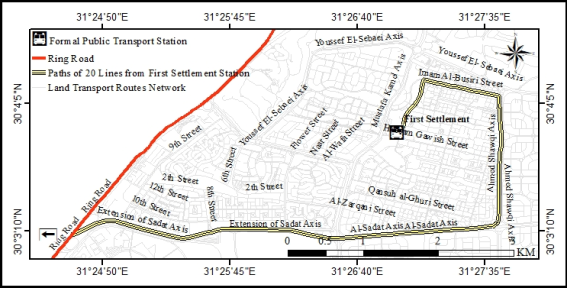
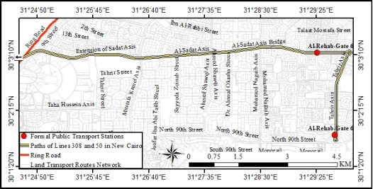
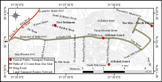
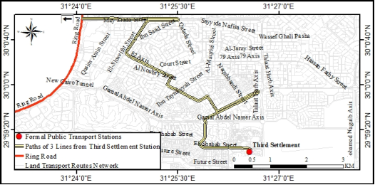
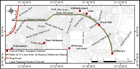
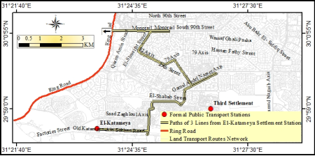
The problem of roads not served by formal public transport paths is exacerbated by the fact that many transport paths share a single path from the bus station to the exit from New Cairo, or from the entrance of the latter to the bus station, as can be seen from
Figures 7 to 12.
Figure 7. The Path of Lines: 30, 81, 101, 109, 196, 131, 133, 602, 1010, 1012, 1019, 1058 from the First Settlement Station to its Exit on the Ring Road 2025.
Figure 8. The Path of Lines: 308, 50, 222, 138, S1 from Al-Rehab Station, Gate 6 to its Exit on the Ring Road 2025.
Figure 9. The Path of Lines: 318, 166, 314, M500, 708, 888, 779, M870, 775, 777, 662, M947 from Dar Misr - Al-Naayib El-Eam Station to its Exit on the Ring Road 2025.
Figure 10. The Path of Lines: 1018, 1111, 1122 from the Third Settlement Station to its Exit on the Ring Road 2025.
Figure 11. The Path of Lines: 354, 1062, M512, 800, Q810, 300, 53, 900, 104, 301 from Al-Hurriya Bus Station to its Exit on the Ring Road 2025.
Figure 12. The Path of Lines: 70, 75, Asmarat from El-Katameya Bus Station to its Exit on the Ring Road 2025.
The Monorail route within New Cairo is a single, two-way line. It enters New Cairo via South 90th Street and heads east until its intersection with Nasr Street. From there, it continues to Mohammed Bin Zayed Road and then to the New Capital after crossing the Middle Ring Road (
Figure 13). The Monorail shares routes with buses and minibuses that use South 90th Street, but it runs exclusively along Mohammed Bin Zayed Road. It also uniquely connects the old inhabited (Cairo - East Nile), the new inhabited (New Cairo), and the most recent inhabited (New Capital).
Figure 13. New Cairo Monorail Route 2025.
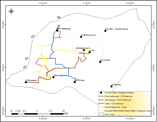
Despite the importance of internal transport within New Cairo, its paths are not shared, but rather overlap in some areas, as is the case with lines NC1, NC2, NC3, and NC4, which connect El-Katameya - First Settlement, Lotus - El-Katameya, Third Settlement - Lotus, and finally, Alf Masnaa - First Settlement, respectively. This means that only five out of ten bus stations in New Cairo connect with each other, as illustrated in
Figure 14.
Figure 14. The Internal Paths of the Formal Public Transport Lines in New Cairo 2025.
Therefore, if all the shared paths were merged into one path, their total length would be 323.8 km, in addition to 33.5 km for the Monorail route within New Cairo only, the total length of the bus, minibus and Monorail paths would be 357.5 km, which is equivalent to only 8.8% of the total length of roads suitable for formal public transport paths, and thus the crisis would widen from 28.7% to 91.2%.
4.2. Spatial Analysis of Formal Public Transport Paths
"Often, transport planning is considered a matter for technicians and economists. However, there are also important human, environmental, and spatial issues that planners cannot ignore. Human issues relate to passenger transport. The primary priority is ensuring a minimum level of service for everyone—in both urban and rural environments—by prioritizing access to workplaces, shopping, leisure activities, and so on. This is known as the right to transport, enshrined in France by the 1982 Orientation Act on Internal Transport. This access is not always guaranteed, particularly in developing countries, as well as in the rural areas of developed countries. Providing a minimum level of access presupposes that service is offered in advance to all urban neighborhoods and, in rural areas, to all villages"
| [1] | Merlin, Pierre. Human Geography. French university presses, Paris. 2000, 579 P. |
[1]
.
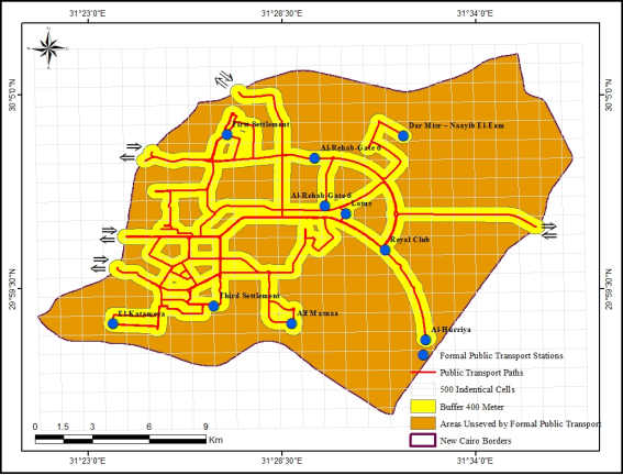
The distribution of formal public transport paths is limited to only 114 out of 314 cells covering New Cairo, meaning that only 63.7% of the total cells covering New Cairo are not served by any formal public transport paths. If we assume that any passenger, regardless of age or gender, can walk 400 meters to reach any of the formal public transport paths, then the area served by the formal public transport paths does not exceed 88.56 km
2, which is equivalent to only 33.54% of the total area of New Cairo. Consequently, the unserved area expands to reach 66.46% (
Figure 15).
Figure 15. Scope of Formal Public Transport Paths Service in New Cairo 2025.
The fact that the formal public transport paths to and from New Cairo have a limited number of exits and entrances also contributes to the crisis of unserved roads, as the entrances or exits of these paths are concentrated on the Ring Road, Al-Moshir Bridge, Majid Al-Futtaim Bridge, and the Golf Tunnel on the Ring Road on the western side, and finally Al-Rehab Bridge on the northern side on the Suez Road, as can be seen through
Figure 15. This means that El-Katameya-Ain Sokhna Road from the south and the Middle Ring Road from the east, as well as most of the Suez Road from the north, do not all have entrances or exits for formal public transport paths, with the exception of the Monorail through the Middle Ring Road. This is naturally due to a simple reason, which is that the direction of vehicle movement from the stations of those paths is limited to the general direction from east to west towards the old inhabited area, as well as the internal direction from north to south or vice versa, with the exception of the only Monorail linking the east and west of New Cairo.
4.3. Transport Tariff
Despite the numerous formal public transportation lines, fares are generally similar, ranging from 12 to 23 Egyptian pounds. Public transport buses cost no more than 12 pounds for a regular bus and up to 23 pounds for an air-conditioned bus. Minibus fares ranged from 18 pounds for a regular minibus to 22 pounds for an air-conditioned minibus, all before the fuel price increase in March 2026. In fact, unifying the transport fare regardless of the number of stations or the distance traveled, pushes passengers to look for a cheaper means of transport for a shorter distance, which has made the unified transport fare another new obstacle to the urbanization of New Cairo.
5. Conclusions
1) Physical infrastructure has successfully developed New Cairo, encompassing 5693 km of roads, distributed unevenly across 22 different road types. New Cairo now boasts trunk, motorway, primary, secondary, tertiary roads, residential and service streets, pedestrian, bridges, tunnels, Monorails, and other infrastructure.
2) Spatially, the density confirms the coverage of roads and streets throughout New Cairo, which is divided into 314 cells, each covering an area of one square kilometer, with roads and streets running across 99.7% of them. This confirms the similarity between the cells in terms of area and road presence, but the variation between them lies in the difference in density from one cell to another.
3) The number of road density categories in New Cairo reaches 9 categories, where the first category rises to more than 51 km/km2, and the last category falls to 0.03 km/km2. In between, the density is tiered in a pyramidal shape, with its apex distributed in limited scattered points within New Cairo and its base located on all its edges, especially the northern, southern and eastern sides.
4) The formal public transport stations contributed to the urbanization of New Cairo through 10 stations, occupying only 3.14% of the cells they cover.
5) The nearest neighbor factor indicates that the distribution pattern of formal public transport stations is scattered but tends towards regularity. The mean center and the weighted mean center by number of paths indicate that their distribution is dispersed far from the mean center of New Cairo, and therefore the distribution of formal public transport stations does not take into account the expansion of New Cairo. However, 107 bus and minibus lines, in addition to the Monorail, run to and from New Cairo, all connecting the different parts of New Cairo on one hand, and connecting it to the old city of Greater Cairo on the other.
6) Approximately 28.7% of the road lengths suitable for vehicles in New Cairo lack formal public transportation. If the shared paths of formal public transportation were combined into a single path, the problem would expand from 28.7% to 91.2%.
7) Only 63.7% of the total cells covering New Cairo are not served by any formal public transport paths, and the area not served by formal public transport means in New Cairo reaches only 66.46%.
8) With the exception of the Monorail, the direction of formal public transport in New Cairo is limited to east (New Cairo) to west (Greater Cairo) or vice versa, and north to south or vice versa.
9) The transport fare is standardized; therefore, its high cost is one of the most significant obstacles to its use.





 Share This Article
 Twitter
 Linked In
 Facebook
 Copy
Copy Download