Objective: Ancient architectures in traditional villages are characterized by high vulnerability and high maintenance costs. Digital three-dimensional (3D) modeling has become a mainstream and efficient technical solution for the protection of ancient architectures. Nevertheless, due to the complex structures and unique flying eaves and warped corners of ancient buildings in traditional villages, 3D modeling based on conventional oblique photogrammetry is prone to model holes and distortions in sheltered eaves areas and internal building spaces. Methods: To address the limitations of traditional oblique photogrammetry, this study proposes an air-ground combined technology that integrates UAV oblique photography images and UAV close aerial videos to realize the 3D reconstruction of ancient buildings. Results: The results show that the air-ground combined technology can effectively supplement the structural information of building eaves and internal spaces of ancient architectures. The holes and distortions of the 3D model are significantly eliminated, and the internal textures of the building are authentic, clear and geometrically accurate. Conclusion: This Technology can effectively solve the defect of missing and distorted models in the 3D modeling of ancient architectures, which possesses promising application potential in the protection of ancient architectural heritage.
This is an Open Access article, distributed under the terms of the Creative Commons Attribution 4.0 International License (http://creativecommons.org/licenses/by/4.0/), which permits unrestricted use, distribution and reproduction in any medium or format, provided the original work is properly cited.
UAV, Oblique Photogrammetry, 3D Modeling, Traditional Village, Heritage Building Protection, Close-Range UAV Video
1. Introduction
Ancient buildings in traditional villages serve as important material carriers of fine traditional Chinese culture, embodying regional folk customs, traditional construction techniques, and historical and humanistic memories, and possess extremely high historical, artistic, and scientific research value
[1]
Ministry of Housing and Urban-Rural Development, Ministry of Culture, Ministry of Finance. (2012). Guiding opinions on strengthening the protection and development of traditional villages [EB/OL]. Retrieved April 15, 2024, from
Chen, D. S., Li, J. J., Xu, W. P., et al. (2025). Exploring the morphological evolution of traditional settlements at large geographic scales using remote sensing AI (In Chinese). Scientia Geographica Sinica, 45(6), 1157–1167.
. Under the combined effects of natural weathering, rainwater erosion, geological disasters, human development, and daily wear, a large number of ancient buildings in traditional villages suffer from component damage, structural aging, and style degradation
[3]
Wu, B., Liu, X. T., Fang, B. N., et al. (2025). Research on traditional village protection based on symbiosis theory under the background of urban renewal: A case study of Xiaozhou Village renovation project in Guangzhou (In Chinese). Chinese Landscape Architecture, 41(3), 60–67.
Yang, Z. G., Wu, S. (2023). Mechanism and path of modern transformation of traditional villages from the perspective of rural revitalization (In Chinese). Agricultural Economy, (10), 50–52.
[5]
Zou, C., Tang, X. X., Shu, C. (2025). Analysis of spatiotemporal evolution pattern and driving factors of traditional villages in Guangdong Province (In Chinese). Research of Soil and Water Conservation, 32(6), 316–326.
. Most traditional ancient buildings have weakened functionality and high maintenance costs, while traditional manual surveying and archiving methods suffer from incomplete records, insufficient precision, and difficulties in long-term data preservation, placing enormous pressure on the protection, restoration, and inheritance of historic architectural heritage
[6]
Liu, C. L., Pu, M. L. (2026). Research on the new endogenous development mechanism and path of tourism-driven traditional villages: A case study of Zhangguying Village in Hunan Province [In Chinese]. Human Geography, 41(3), 151–163.
Zeng, C., Liu, P. L., Gong, W. J., et al. (2025). Research on protection and utilization mode of traditional villages based on landscape fragmentation characteristics (In Chinese). Geographical Research, 44(3), 770–784.
Wang, J., Zhou, K. (2026). Construction path of new quality productivity in tourism-oriented traditional villages driven by space production (In Chinese). Journal of China Agricultural University, 31(9), 161–171.
. Therefore, research on digital preservation and precise protection of historic architectural heritage has become a hotspot in the fields of heritage conservation, surveying and mapping, rural cultural revitalization, and digital museology
[2]
Chen, D. S., Li, J. J., Xu, W. P., et al. (2025). Exploring the morphological evolution of traditional settlements at large geographic scales using remote sensing AI (In Chinese). Scientia Geographica Sinica, 45(6), 1157–1167.
Wu, B., Liu, X. T., Fang, B. N., et al. (2025). Research on traditional village protection based on symbiosis theory under the background of urban renewal: A case study of Xiaozhou Village renovation project in Guangzhou (In Chinese). Chinese Landscape Architecture, 41(3), 60–67.
Yang, Z. G., Wu, S. (2023). Mechanism and path of modern transformation of traditional villages from the perspective of rural revitalization (In Chinese). Agricultural Economy, (10), 50–52.
[5]
Zou, C., Tang, X. X., Shu, C. (2025). Analysis of spatiotemporal evolution pattern and driving factors of traditional villages in Guangdong Province (In Chinese). Research of Soil and Water Conservation, 32(6), 316–326.
Liu, C. L., Pu, M. L. (2026). Research on the new endogenous development mechanism and path of tourism-driven traditional villages: A case study of Zhangguying Village in Hunan Province [In Chinese]. Human Geography, 41(3), 151–163.
Zeng, C., Liu, P. L., Gong, W. J., et al. (2025). Research on protection and utilization mode of traditional villages based on landscape fragmentation characteristics (In Chinese). Geographical Research, 44(3), 770–784.
Wang, J., Zhou, K. (2026). Construction path of new quality productivity in tourism-oriented traditional villages driven by space production (In Chinese). Journal of China Agricultural University, 31(9), 161–171.
Yuan, C., Hu, Z. P., Li, T. Y., et al. (2025). Framework construction and case analysis of traditional village protection: Based on the assemblage place theory (In Chinese). Progress in Geography, 44(11), 2404–2420.
Tong, J. M., Shi, A. S. (2025). Internal mechanism, practical dilemmas and legal approaches of cultural relic restoration in non-state-owned ancient buildings (In Chinese). Business Research, 32(3), 120–128.
Yang, B. X. (2024). Protection and inheritance of cultural relic buildings in traditional villages (In Chinese). Building Science, 40(11), 193.
[2-11]
.
With the rapid development of UAV remote sensing, photogrammetry, and 3D reconstruction technology, digital 3D modeling has gradually become the mainstream technical means for the digital protection of historic architectural heritage, owing to its advantages of high efficiency, non-destructiveness, high precision, and excellent visualization
[11]
Yang, B. X. (2024). Protection and inheritance of cultural relic buildings in traditional villages (In Chinese). Building Science, 40(11), 193.
[12]
Liu, Y., Liao, D. J., Wang, C. G., et al. (2020). 3D modeling of ancient buildings supported by UAV close-range photography (In Chinese). Bulletin of Surveying and Mapping, (11), 112–115.
Zhang, W. C., Fan, H. Y., Liu, Y. J., et al. (2019). Ancient building reconstruction by 3D laser point cloud combined with UAV images (In Chinese). Bulletin of Surveying and Mapping, (11), 130–133, 144.
. Among these technologies, UAV oblique photogrammetry can rapidly acquire multi-angle image data of large-scale scenes and efficiently complete the 3D reconstruction of the overall scene of traditional villages and the external contours of ancient buildings, greatly improving the efficiency of ancient building modeling. It has been widely applied in engineering scenarios such as heritage surveys, reality modeling, and style monitoring
[13]
Zhang, W. C., Fan, H. Y., Liu, Y. J., et al. (2019). Ancient building reconstruction by 3D laser point cloud combined with UAV images (In Chinese). Bulletin of Surveying and Mapping, (11), 130–133, 144.
Hu, Y. L., Chen, Y. B., Zheng, Z. H., et al. (2019). 3D reconstruction application of ancient villages based on air-ground multi-view images (In Chinese). Science of Surveying and Mapping, 44(4), 139–145.
Du, X. (2025). Quality and stability analysis of slope excavation based on oblique photography (In Chinese) [Master's thesis, Guilin University of Technology].
[13-15]
. However, in the refined modeling of ancient buildings in traditional villages, conventional single oblique photogrammetry still has significant technical limitations
[12]
Liu, Y., Liao, D. J., Wang, C. G., et al. (2020). 3D modeling of ancient buildings supported by UAV close-range photography (In Chinese). Bulletin of Surveying and Mapping, (11), 112–115.
Du, X. (2025). Quality and stability analysis of slope excavation based on oblique photography (In Chinese) [Master's thesis, Guilin University of Technology].
[12, 15]
. Traditional ancient buildings generally feature flying eaves, warped corners, layered and staggered layouts, and complex structures. The overhanging eave structures easily form photographic blind zones and occluded areas, resulting in frequent model holes, structural distortions, missing surface textures, and incomplete internal structures in 3D models constructed solely from aerial oblique photography data. These issues make it difficult to meet the precision requirements for refined modeling, disease analysis, restoration design, and digital archiving of historic architectural heritage
[12]
Liu, Y., Liao, D. J., Wang, C. G., et al. (2020). 3D modeling of ancient buildings supported by UAV close-range photography (In Chinese). Bulletin of Surveying and Mapping, (11), 112–115.
Zhang, W. C., Fan, H. Y., Liu, Y. J., et al. (2019). Ancient building reconstruction by 3D laser point cloud combined with UAV images (In Chinese). Bulletin of Surveying and Mapping, (11), 130–133, 144.
Sun, Y. S., Zhang, L., Ai, H. B., et al. (2018). Review of key technologies in oblique image matching and 3D modeling (In Chinese). Remote Sensing Information, 33(2), 1–8.
[12, 13, 16]
.
To address the technical shortcomings of single UAV oblique photogrammetry and solve the problems of modeling artifacts and structural missing in occluded areas of heritage buildings, multi-scale UAV image integration for 3D modeling has been gradually applied in the digital preservation of historic architectural heritage
[17]
Lan, G. L., Zhang, M. M., Xue, Y. A., et al. (2026). 3D modeling and visualization of campus real scene based on oblique photography (In Chinese). Bulletin of Surveying and Mapping, (S2), 274–278.
[18]
Chen, M. Q., Li, F. P., Bai, L. M., et al. (2026). 3D modeling of dense building areas based on UAV oblique photogrammetry and LiDAR point cloud (In Chinese). Bulletin of Surveying and Mapping, (6), 119–123.
Li, Y. Z., Zheng, H. Y., Zhang, L., et al. (2026). Research on 3D modeling and protection of ancient buildings based on UAV oblique photogrammetry technology (In Chinese). Science and Technology Innovation Herald, (13), 17–20.
[17-19]
. By integrating large-scale aerial oblique photography data with close-range fine video-frame data, comprehensive data complementarity between the external overall style and internal detailed structures of heritage buildings can be achieved, effectively avoiding the data acquisition defects of a single perspective. Based on this, this study takes the Gangli Ancestral Hall, a provincial-level historic architectural heritage located in Qingtong Village, Zhanjiang City, as the research object. A multi-scale UAV image integration method combining UAV oblique photography images with frame extraction from close-range blind-zone aerial videos is adopted to conduct 3D reconstruction experiments, optimizing the modeling effects of complex structures and occluded areas of heritage buildings, repairing mesh holes and artifacts, and constructing a 3D reality model of heritage buildings with faithful textures, complete structures, and reliable geometric precision.
This study aims to explore an efficient and high-precision 3D modeling method adapted to the characteristics of ancient buildings in traditional villages, effectively solving the problems of structural missing and model distortion in traditional modeling methods. The research provides technical support for the digital archiving, disease monitoring, restoration, virtual display, and cultural inheritance of historic architectural heritage in traditional villages, while offering feasible practical references and technical references for similar digital protection projects of ancient buildings.
2. Study Area
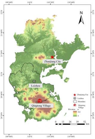
Qingtong Village is under the jurisdiction of Yingli Town, Leizhou City, Zhanjiang City, Guangdong Province, and is located in the eastern part of Yingli Town (Figure 1). The village was selected into the second batch of "Chinese Traditional Villages" in 2013. Founded in the early years of the Longqing reign of the Ming Dynasty, the village has a history of more than 400 years. Well-preserved magnificent ancestral halls of the Qing Dynasty and contiguous ancient residential mansions remain in the village, demonstrating profound historical and cultural heritage. The village is oriented south-facing, surrounded by an open courtyard with no tall obstructions, providing good natural illumination for photogrammetric data acquisition.
This study takes the Gangli Ancestral Hall, a provincial-level historic architectural heritage in Qingtong Village, as the research case. It features a traditional Chinese gable-and-hip roof with anout 1.2 m eave overhang; the eave height is approximately 3.2 m above ground, with decorative bracket sets (dougong) beneath the eave. Building materials include gray brick walls, red ceramic tile roof, wooden structural frame, and painted wood decorations. The rich structural layers, prominent flying eaves and warped corners, significant eave overhang occlusion, and complex traditional brick-wood interior space make this building highly suitable for digital 3D modeling experiments and effectively testing the repair and restoration capabilities of the multi-scale UAV image integration modeling method for complex historic building structures.
Figure 1. Geographical location of Qingtong Village, Zhanjiang City, Guangdong Province.
3. Materials and Methods
3.1. Equipment Selection
In this study, field image acquisition and control point coordinate collection were conducted using a DJI Mavic 3E industrial-grade surveying UAV and a Hi-Target iRTK5 GNSS receiver, respectively. The DJI Mavic 3E is equipped with an onboard RTK module, enabling centimeter-level positioning and supporting oblique photogrammetry mode. The UAV carries a 4/3 CMOS camera with 12 MP effective pixels, a mechanical shutter, and an equivalent focal length of 24 mm (field of view approximately 84°). It features omnidirectional obstacle avoidance and an intelligent return-to-home system, making it adaptable to full-coverage surveying operations in complex terrain. The Hi-Target iRTK5 is a new-generation intelligent GNSS measurement device, primarily used for control point deployment and image coordinate precision correction in this study. The iRTK5 is compatible with multi-constellation signals including BeiDou, GPS, GLONASS, and GALILEO, and can improve positioning precision and stability in complex environments through multi-system joint positioning. It supports RTK differential, network differential, and satellite-station differential modes, enabling single-device centimeter-level high-precision positioning with an expected horizontal accuracy and vertical accuracy.
3.2. UAV Photogrammetry
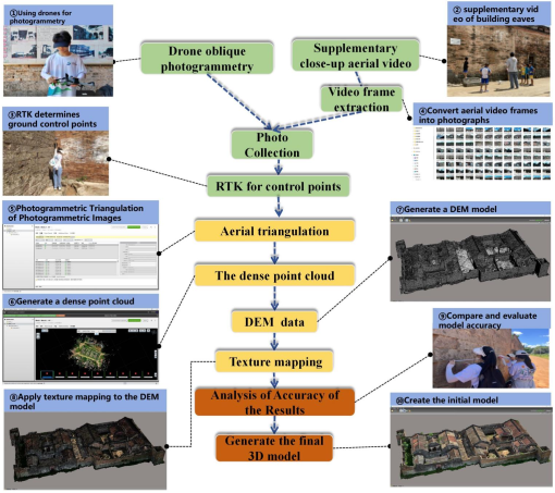
The data acquisition in this study was divided into two parts: UAV photogrammetry and close-range blind-zone aerial photography. The two types of data were collected complementarily, taking into account both the overall building morphology and detailed fine features. The technical workflow is shown in Figure 2.
UAV photogrammetry was completed using the DJI Mavic 3E UAV in oblique photography mode. Full-coverage aerial photography was conducted with the established parameters of 80% forward overlap and 80% side overlap. The oblique angle was uniformly set to −45°, the relative flight altitude was determined as 12 m based on the surrounding surveying flight coverage and building conditions, and the flight speed was set to 12 m/s. The 12 m relative altitude was selected to achieve a ground sampling distance (GSD) of approximately 2.5 cm while maintaining a safe clearance above the building roof (maximum building height ≈ 8.5 m). The 80% forward/side overlap was chosen to ensure robust feature matching and dense point generation for the complex, ornament-rich heritage facade. The −45° viewing angle balances vertical roof coverage and oblique facade coverage, ensuring both horizontal and vertical surfaces are imaged at incidence angles within 45° of the surface normal. The 12 m/s flight speed maintains image sharpness. The oblique images were acquired (image dimensions 8192 × 5460 pixels; auto-exposure mode). The mission consisted of 2 parallel strips. Network RTK was enabled throughout the mission with fixed-solution (Fixed) status maintained. Through oblique photogrammetry, the overall contour, roof structure, overall layout, and surrounding environment information of the heritage building can be completely acquired, constructing the overall framework foundation of the 3D model and ensuring the accuracy of the model overall scale, spatial position, and terrain pattern.
Figure 2. Technical workflow of integrated modeling with photogrammetry and close-range UAV video-frame.
3.3. Aerial Data Fusion Method
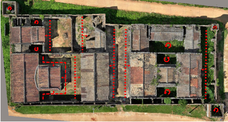
After completing the oblique photogrammetry, targeting the photographic blind zones of conventional aerial oblique photography, such as the lower parts of the overhanging eaves of the Gangli Ancestral Hall and the internal halls of the building, the UAV was maneuvered into the target areas to conduct close-range aerial video acquisition. All close-range flights were conducted in manual mode by an experienced UAV pilot. A minimum standoff distance of 1.0 m from the building surface was maintained, and a visual observer was stationed at ground level to monitor clearance. The omnidirectional obstacle sensing system was enabled, although the pilot maintained full manual control as the primary safety mechanism. During flight operations, low-speed circling and layer-by-layer progressive flight methods were adopted (Figure 3) to completely cover the detailed features of all occluded areas and internal structures. The resolution of the acquired video was set to 1920×1080, and the frame rate was stably maintained at 30 fps, ensuring clear images without significant jitter and meeting the precision requirements of subsequent 3D reconstruction for close-range data.
The UAV aerial flight altitude was controlled within a narrow range of 2.4 m to 3.2 m to adapt to the complex spatial scale of the interior and under-eave areas of the heritage building. After the aerial photography task was completed, the acquired high-definition video data underwent systematic post-processing. The frames were first extracted at a fixed time interval of 0.05 seconds from the raw video. The close-range frames and oblique images were co-registered through joint aerial triangulation in ContextCapture, no manual tie points were introduced between the two image groups. The ContextCapture self-calibration bundle adjustment was used, simultaneously estimating interior orientation parameters (focal length, principal point, radial and tangential distortion coefficients) for each camera group during triangulation. All images were assigned equal weight in the bundle adjustment; no special alignment constraints or weighting schemes were applied between the oblique and close-range image groups.
Figure 3. Planned flight route for close-range aerial video.
3.4. 3D Model Construction
The ContextCapture software was used to conduct 3D modeling of the Gangli Ancestral Hall. In the software, the photo data acquired by the UAV and the photo data formed by frame extraction from the UAV blind-zone aerial photography were combined to form a photo dataset. A total of 8 ground control points (GCPs) were used for model adjustment, ensuring good three-dimensional geometric intersection. Six independent check points were established separately from the GCPs and were not used in the bundle adjustment or model registration, being reserved exclusively for accuracy validation. The coordinate reference system was the World Geodetic System 1984 (WGS84). All GCP and check point observations were recorded in network RTK Fixed mode. The control point data measured by RTK were used for point marking and correction to ensure the accuracy of the geospatial information of the image data, thereby improving the positional precision of the model (Figure 2). Aerial triangulation was used to precisely calculate the 3D spatial coordinates of feature points, providing key data for generating high-quality 3D models. The software then automatically generated dense point clouds from the image data, which were further converted into 3D meshes. After the preliminary generation of the 3D model, the detail optimization and texture mapping stages were entered. By adjusting texture mapping and enhancing light and shadow effects, the visual realism of the model was significantly improved, enabling the faithful restoration of the materials and colors of each building component.
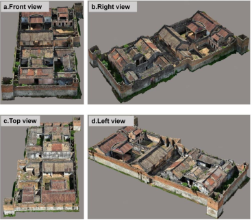
Figure 4. 3D modeling effect of the Gangli Ancestral Hall.
4. Results
4.1. Overall Effect Analysis of Ancient Building 3D Modeling
This study selected the representative Gangli Ancestral Hall in Qingtong Village for refined 3D modeling. During the modeling process, based on the multi-angle images acquired through the aforementioned flight planning, high-precision reality 3D models were generated through steps including aerial triangulation, dense matching, and texture mapping. From the modeling results (Figure 4), the gable and hip roof, dougong bracket sets, and wood carving decorations of the Gangli Ancestral Hall were clearly restored, the roof tile textures were authentic, and the three-dimensional relationships of the under-eave beam frames were accurately expressed.
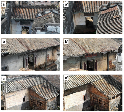
Figure 5. Comparative analysis of 3D models before and after the introduction of close-range aerial supplementary data (a, b, c: original models; a', b', c': models after supplementary data).
Comparing the 3D models before and after the introduction of close-range aerial supplementary data reveals that in the initial models without close-range aerial supplementary data, obvious mesh holes generally existed in the original photographic blind zones, such as the lower parts of the deeply overhanging eaves and the internal halls with large depth of the Gangli Ancestral Hall. The contours of some overhanging structures showed artifacts and misalignment, the textures of internal walls and beam frames showed large-area blurring and missing, and the internal spatial structure of the building could not be completely presented. The overall integrity was difficult to meet the requirements for digital archiving and subsequent analysis of heritage buildings (Figure 5a, Figure 5b, and Figure 5c). After adding the blind-zone supplementary data acquired by close-range UAV video-frame, the mesh holes and structural artifacts in the aforementioned areas were significantly reduced and corrected. The detailed structures originally occluded by the eaves, such as dougong bracket components and sparrow brace wood carvings, were substantially recovered. The textures of the red brick walls and wooden beam frames inside the building were clear and natural, and the spatial relationships were accurately expressed (Figure 5a', Figure 5b', and Figure 5c'). The 3D model of the Gangli Ancestral Hall constructed based on UAV oblique photography combined with close-range aerial supplementary data completely presents the external contour of the building and the details of various internal components. Compared with the single oblique photography modeling results, the model integrity and visual realism have been significantly improved, and the model can clearly reflect the original architectural style and detailed features of the Gangli Ancestral Hall.
4.2. Precision Analysis of the Ancient Building Model
In this study, the precision of the 3D model of the Gangli Ancestral Hall was evaluated by comparing the field-measured lengths of characteristic building components with the lengths measured from the 3D model. It should be noted that the following four line-length measurements constitute a small validation sample and provide indicative rather than comprehensive accuracy assessment of the entire model. To ensure the objectivity and representativeness of the precision evaluation results, four groups of characteristic line segments were uniformly deployed within the entire area of the Gangli Ancestral Hall. RTK technology was used to collect the spatial coordinates of the endpoints of the characteristic line segments in the field, while a tape measure was used to obtain the line segment lengths. The above measurement results were used as the ground truth baseline for precision evaluation. In addition to line measurements, point-level residuals were computed for the 6 independent check points.
Table 1. Comparison between actual lengths and model-measured lengths of the ancient building.
Ancient Building Name
Actual Length / Length in Model (m)
Measurement Point
1
2
3
4
Gangli Ancestral Hall
Actual Length (m)
2.10
4.45
1.99
4.42
Length in Model (m)
2.10
4.45
1.99
4.41
By comparing and analyzing the ground truth building lengths with the 3D model measurement results, the precision of this integrated modeling result was calculated (Table 1). For the 6 independent check points, the mean horizontal residual was 8.3 mm and the mean vertical residual was 12.6 mm. Within the measured sample, the fused model exhibited sub-centimeter to centimeter-level dimensional accuracy; however, given the limited validation sample, no claim is made regarding the overall model accuracy across the entire building surface. Compared with the modeling results using only oblique photography data, after integrating the close-range aerial video supplementary data, the area of under-eave occluded regions was reduced about 60%. This result indicates that supplementing close-range blind-zone aerial photography data can effectively correct the spatial coordinate deviations in occluded areas, alleviate the problems of information missing and mesh hole artifacts caused by complex building structures and occlusion in single oblique photography, significantly improve the completeness and precision of refined modeling of complex heritage buildings, and further verify the reliability and applicability of the UAV oblique photogrammetry and close-range aerial video fusion modeling method proposed in this paper.
4.3. Application Analysis of the Ancient Building Model
High-precision and high-integrity 3D reality models of ancient buildings can play a core supporting role in multiple aspects of the protection and inheritance of ancient buildings in traditional villages: 1) Supporting the permanent digital archiving of historic architectural heritage. Traditional two-dimensional drawings and manual surveying records can only preserve the local dimensions and contour information of buildings, and cannot completely retain the spatial structures, detailed textures, and current styles of ancient buildings. The high-precision 3D models with absolute geographic coordinates constructed in this study can non-destructively and completely store the full-dimensional information of ancient buildings, forming digital archives of ancient buildings that can be preserved for a long time and accessed at any time. Even if ancient buildings are damaged by natural or human factors in the future, the digital archives can be relied upon to completely restore the original appearance of the buildings, preserving complete digital genes for ancient buildings. 2) Providing data support for ancient building disease detection and restoration design. Relying on high-precision 3D models, technicians can quickly obtain the dimensional parameters and spatial forms of any component of ancient buildings. By comparing model data from different periods, the locations and ranges of diseases such as component weathering, structural deformation, and wall cracking can be precisely located, enabling quantitative assessment of diseases and providing a scientific basis for disease management. In ancient building restoration projects, designers can directly conduct virtual restoration on 3D models, compare the implementation effects of different restoration schemes, optimize restoration design, improve the scientific nature of restoration projects while maximizing the preservation of historical information of ancient buildings, and reduce engineering trial-and-error costs. 3) Empowering the virtual display and dissemination of ancient building culture. The 3D reality models generated in this study can be directly used to develop products such as online virtual exhibition halls, mobile immersive roaming, and digital cultural and creative products, breaking the temporal and spatial limitations of physical visits. This allows the public to closely observe the construction details and artistic features of traditional Lingnan ancient buildings online, deeply perceive the historical and cultural connotations of traditional villages. This not only provides a new carrier for the inheritance and dissemination of ancient building culture, but also empowers the development of cultural tourism industries in traditional villages, supporting rural cultural revitalization.
5. Conclusion
Aiming at the problems of mesh holes, structural artifacts, and insufficient precision caused by flying eave occlusion and internal space photographic blind zones in the refined modeling of Lingnan traditional heritage buildings using conventional single UAV oblique photography technology, this paper proposes a multi-scale UAV image integration 3D modeling method combining UAV oblique photography with frame extraction from close-range blind-zone aerial videos. Modeling experiments were conducted with the Gangli Ancestral Hall, a provincial-level heritage in Qingtong Village, Zhanjiang City, Guangdong Province, as the research object. The experimental results show that this method can effectively integrate image data of different scales and perspectives, fill the data gaps of single aerial oblique photography in occluded areas and internal spaces. The final generated 3D model meets the requirements for digital archiving and subsequent protection research of heritage buildings in three dimensions: structural integrity, geometric precision, and texture authenticity. Compared with the single oblique photography modeling results, the modeling precision of occluded areas has been significantly improved.
The overall workflow of this technical scheme is clear, field operations are convenient, and equipment requirements are low. High-precision 3D modeling of heritage buildings can be completed without large-scale ground surveying equipment, making it suitable for promotion and application in grassroots rural heritage protection work. It can provide reliable technical support for the digital preservation, disease monitoring, restoration design, and cultural dissemination of heritage buildings in traditional villages, and also offer replicable practical references for similar digital protection projects of small and medium-sized heritage buildings. It should be acknowledged that this study is based on a single heritage building case and a relatively limited validation sample; the generalizability of the proposed multi-scale UAV image integration framework to other architectural typologies, larger building complexes, or different environmental conditions requires further investigation with additional case studies. Future research can further explore methods combining deep learning for automatic mesh hole patching and optimizing texture mapping efficiency, continuously improving the automation level and result quality of heritage building 3D modeling, and promoting digital technologies to better serve rural heritage protection and cultural inheritance work.
Abbreviations
UAV
Unmanned Aerial Vehicle
3D
Three-Dimensional
RTK
Real-time Kinematic
GNSS
Global Navigation Satellite System
GIS
Geographic Information System
Acknowledgments
The authors would like to thank the staff of Qingtong Village for their assistance during field data collection.
Author Contributions
Yang Xin: Conceptualization, Funding acquisition, Methodology, Writing – original draft
Han Xinru: Formal Analysis, Writing – review & editing
Funding
This work was supported by the Guangdong Provincial Philosophy and Social Sciences Planning Project (Grant No. GD26YGG30) and the Zhanjiang Philosophy and Social Sciences Planning Project (Grant Nos. ZJ23QN05, ZJ24QN13).
Data Availability Statement
All data used in this study, including UAV oblique imagery, close-range aerial video frames, ground control point and check point coordinate datasets, and the generated 3D model assets, are available from the corresponding author upon reasonable request. No proprietary or commercially sensitive data were used in this research.
Conflicts of Interest
The authors declare no conflicts of interest.
References
[1]
Ministry of Housing and Urban-Rural Development, Ministry of Culture, Ministry of Finance. (2012). Guiding opinions on strengthening the protection and development of traditional villages [EB/OL]. Retrieved April 15, 2024, from
Chen, D. S., Li, J. J., Xu, W. P., et al. (2025). Exploring the morphological evolution of traditional settlements at large geographic scales using remote sensing AI (In Chinese). Scientia Geographica Sinica, 45(6), 1157–1167.
Wu, B., Liu, X. T., Fang, B. N., et al. (2025). Research on traditional village protection based on symbiosis theory under the background of urban renewal: A case study of Xiaozhou Village renovation project in Guangzhou (In Chinese). Chinese Landscape Architecture, 41(3), 60–67.
Yang, Z. G., Wu, S. (2023). Mechanism and path of modern transformation of traditional villages from the perspective of rural revitalization (In Chinese). Agricultural Economy, (10), 50–52.
[5]
Zou, C., Tang, X. X., Shu, C. (2025). Analysis of spatiotemporal evolution pattern and driving factors of traditional villages in Guangdong Province (In Chinese). Research of Soil and Water Conservation, 32(6), 316–326.
Liu, C. L., Pu, M. L. (2026). Research on the new endogenous development mechanism and path of tourism-driven traditional villages: A case study of Zhangguying Village in Hunan Province [In Chinese]. Human Geography, 41(3), 151–163.
Zeng, C., Liu, P. L., Gong, W. J., et al. (2025). Research on protection and utilization mode of traditional villages based on landscape fragmentation characteristics (In Chinese). Geographical Research, 44(3), 770–784.
Wang, J., Zhou, K. (2026). Construction path of new quality productivity in tourism-oriented traditional villages driven by space production (In Chinese). Journal of China Agricultural University, 31(9), 161–171.
Yuan, C., Hu, Z. P., Li, T. Y., et al. (2025). Framework construction and case analysis of traditional village protection: Based on the assemblage place theory (In Chinese). Progress in Geography, 44(11), 2404–2420.
Tong, J. M., Shi, A. S. (2025). Internal mechanism, practical dilemmas and legal approaches of cultural relic restoration in non-state-owned ancient buildings (In Chinese). Business Research, 32(3), 120–128.
Yang, B. X. (2024). Protection and inheritance of cultural relic buildings in traditional villages (In Chinese). Building Science, 40(11), 193.
[12]
Liu, Y., Liao, D. J., Wang, C. G., et al. (2020). 3D modeling of ancient buildings supported by UAV close-range photography (In Chinese). Bulletin of Surveying and Mapping, (11), 112–115.
Zhang, W. C., Fan, H. Y., Liu, Y. J., et al. (2019). Ancient building reconstruction by 3D laser point cloud combined with UAV images (In Chinese). Bulletin of Surveying and Mapping, (11), 130–133, 144.
Hu, Y. L., Chen, Y. B., Zheng, Z. H., et al. (2019). 3D reconstruction application of ancient villages based on air-ground multi-view images (In Chinese). Science of Surveying and Mapping, 44(4), 139–145.
Du, X. (2025). Quality and stability analysis of slope excavation based on oblique photography (In Chinese) [Master's thesis, Guilin University of Technology].
[16]
Sun, Y. S., Zhang, L., Ai, H. B., et al. (2018). Review of key technologies in oblique image matching and 3D modeling (In Chinese). Remote Sensing Information, 33(2), 1–8.
[17]
Lan, G. L., Zhang, M. M., Xue, Y. A., et al. (2026). 3D modeling and visualization of campus real scene based on oblique photography (In Chinese). Bulletin of Surveying and Mapping, (S2), 274–278.
[18]
Chen, M. Q., Li, F. P., Bai, L. M., et al. (2026). 3D modeling of dense building areas based on UAV oblique photogrammetry and LiDAR point cloud (In Chinese). Bulletin of Surveying and Mapping, (6), 119–123.
Li, Y. Z., Zheng, H. Y., Zhang, L., et al. (2026). Research on 3D modeling and protection of ancient buildings based on UAV oblique photogrammetry technology (In Chinese). Science and Technology Innovation Herald, (13), 17–20.
Xin, Y., Dongping, C., Yan, W., Jiahong, L., Minhui, C., et al. (2026). Application of UAV Oblique Photogrammetry and
Close-range Aerial Video Fusion Technology in 3D Modeling of Ancient Village Buildings. International Journal of Architecture, Arts and Applications, 12(4), 161-169. https://doi.org/10.11648/j.ijaaa.20261204.12
Xin, Y.; Dongping, C.; Yan, W.; Jiahong, L.; Minhui, C., et al. Application of UAV Oblique Photogrammetry and
Close-range Aerial Video Fusion Technology in 3D Modeling of Ancient Village Buildings. Int. J. Archit. Arts Appl.2026, 12(4), 161-169. doi: 10.11648/j.ijaaa.20261204.12
Xin Y, Dongping C, Yan W, Jiahong L, Minhui C, et al. Application of UAV Oblique Photogrammetry and
Close-range Aerial Video Fusion Technology in 3D Modeling of Ancient Village Buildings. Int J Archit Arts Appl. 2026;12(4):161-169. doi: 10.11648/j.ijaaa.20261204.12
@article{10.11648/j.ijaaa.20261204.12,
  author = {Yang Xin and Chen Dongping and Wu Yan and Liang Jiahong and Cai Minhui and Li Zengcai and Dong Zhaoji and Mu Jian and Liang Yushan and Han Xinru},
  title = {Application of UAV Oblique Photogrammetry and
Close-range Aerial Video Fusion Technology in 3D Modeling of Ancient Village Buildings},
  journal = {International Journal of Architecture, Arts and Applications},
  volume = {12},
  number = {4},
  pages = {161-169},
  doi = {10.11648/j.ijaaa.20261204.12},
  url = {https://doi.org/10.11648/j.ijaaa.20261204.12},
  eprint = {https://article.sciencepublishinggroup.com/pdf/10.11648.j.ijaaa.20261204.12},
  abstract = {Objective: Ancient architectures in traditional villages are characterized by high vulnerability and high maintenance costs. Digital three-dimensional (3D) modeling has become a mainstream and efficient technical solution for the protection of ancient architectures. Nevertheless, due to the complex structures and unique flying eaves and warped corners of ancient buildings in traditional villages, 3D modeling based on conventional oblique photogrammetry is prone to model holes and distortions in sheltered eaves areas and internal building spaces. Methods: To address the limitations of traditional oblique photogrammetry, this study proposes an air-ground combined technology that integrates UAV oblique photography images and UAV close aerial videos to realize the 3D reconstruction of ancient buildings. Results: The results show that the air-ground combined technology can effectively supplement the structural information of building eaves and internal spaces of ancient architectures. The holes and distortions of the 3D model are significantly eliminated, and the internal textures of the building are authentic, clear and geometrically accurate. Conclusion: This Technology can effectively solve the defect of missing and distorted models in the 3D modeling of ancient architectures, which possesses promising application potential in the protection of ancient architectural heritage.},
 year = {2026}
}
TY  - JOUR
T1  - Application of UAV Oblique Photogrammetry and
Close-range Aerial Video Fusion Technology in 3D Modeling of Ancient Village Buildings
AU  - Yang Xin
AU  - Chen Dongping
AU  - Wu Yan
AU  - Liang Jiahong
AU  - Cai Minhui
AU  - Li Zengcai
AU  - Dong Zhaoji
AU  - Mu Jian
AU  - Liang Yushan
AU  - Han Xinru
Y1  - 2026/11/14
PY  - 2026
N1  - https://doi.org/10.11648/j.ijaaa.20261204.12
DO  - 10.11648/j.ijaaa.20261204.12
T2  - International Journal of Architecture, Arts and Applications
JF  - International Journal of Architecture, Arts and Applications
JO  - International Journal of Architecture, Arts and Applications
SP  - 161
EP  - 169
PB  - Science Publishing Group
SN  - 2472-1131
UR  - https://doi.org/10.11648/j.ijaaa.20261204.12
AB  - Objective: Ancient architectures in traditional villages are characterized by high vulnerability and high maintenance costs. Digital three-dimensional (3D) modeling has become a mainstream and efficient technical solution for the protection of ancient architectures. Nevertheless, due to the complex structures and unique flying eaves and warped corners of ancient buildings in traditional villages, 3D modeling based on conventional oblique photogrammetry is prone to model holes and distortions in sheltered eaves areas and internal building spaces. Methods: To address the limitations of traditional oblique photogrammetry, this study proposes an air-ground combined technology that integrates UAV oblique photography images and UAV close aerial videos to realize the 3D reconstruction of ancient buildings. Results: The results show that the air-ground combined technology can effectively supplement the structural information of building eaves and internal spaces of ancient architectures. The holes and distortions of the 3D model are significantly eliminated, and the internal textures of the building are authentic, clear and geometrically accurate. Conclusion: This Technology can effectively solve the defect of missing and distorted models in the 3D modeling of ancient architectures, which possesses promising application potential in the protection of ancient architectural heritage.
VL  - 12
IS  - 4
ER  -
Xin, Y., Dongping, C., Yan, W., Jiahong, L., Minhui, C., et al. (2026). Application of UAV Oblique Photogrammetry and
Close-range Aerial Video Fusion Technology in 3D Modeling of Ancient Village Buildings. International Journal of Architecture, Arts and Applications, 12(4), 161-169. https://doi.org/10.11648/j.ijaaa.20261204.12
Xin, Y.; Dongping, C.; Yan, W.; Jiahong, L.; Minhui, C., et al. Application of UAV Oblique Photogrammetry and
Close-range Aerial Video Fusion Technology in 3D Modeling of Ancient Village Buildings. Int. J. Archit. Arts Appl.2026, 12(4), 161-169. doi: 10.11648/j.ijaaa.20261204.12
Xin Y, Dongping C, Yan W, Jiahong L, Minhui C, et al. Application of UAV Oblique Photogrammetry and
Close-range Aerial Video Fusion Technology in 3D Modeling of Ancient Village Buildings. Int J Archit Arts Appl. 2026;12(4):161-169. doi: 10.11648/j.ijaaa.20261204.12
@article{10.11648/j.ijaaa.20261204.12,
  author = {Yang Xin and Chen Dongping and Wu Yan and Liang Jiahong and Cai Minhui and Li Zengcai and Dong Zhaoji and Mu Jian and Liang Yushan and Han Xinru},
  title = {Application of UAV Oblique Photogrammetry and
Close-range Aerial Video Fusion Technology in 3D Modeling of Ancient Village Buildings},
  journal = {International Journal of Architecture, Arts and Applications},
  volume = {12},
  number = {4},
  pages = {161-169},
  doi = {10.11648/j.ijaaa.20261204.12},
  url = {https://doi.org/10.11648/j.ijaaa.20261204.12},
  eprint = {https://article.sciencepublishinggroup.com/pdf/10.11648.j.ijaaa.20261204.12},
  abstract = {Objective: Ancient architectures in traditional villages are characterized by high vulnerability and high maintenance costs. Digital three-dimensional (3D) modeling has become a mainstream and efficient technical solution for the protection of ancient architectures. Nevertheless, due to the complex structures and unique flying eaves and warped corners of ancient buildings in traditional villages, 3D modeling based on conventional oblique photogrammetry is prone to model holes and distortions in sheltered eaves areas and internal building spaces. Methods: To address the limitations of traditional oblique photogrammetry, this study proposes an air-ground combined technology that integrates UAV oblique photography images and UAV close aerial videos to realize the 3D reconstruction of ancient buildings. Results: The results show that the air-ground combined technology can effectively supplement the structural information of building eaves and internal spaces of ancient architectures. The holes and distortions of the 3D model are significantly eliminated, and the internal textures of the building are authentic, clear and geometrically accurate. Conclusion: This Technology can effectively solve the defect of missing and distorted models in the 3D modeling of ancient architectures, which possesses promising application potential in the protection of ancient architectural heritage.},
 year = {2026}
}
TY  - JOUR
T1  - Application of UAV Oblique Photogrammetry and
Close-range Aerial Video Fusion Technology in 3D Modeling of Ancient Village Buildings
AU  - Yang Xin
AU  - Chen Dongping
AU  - Wu Yan
AU  - Liang Jiahong
AU  - Cai Minhui
AU  - Li Zengcai
AU  - Dong Zhaoji
AU  - Mu Jian
AU  - Liang Yushan
AU  - Han Xinru
Y1  - 2026/11/14
PY  - 2026
N1  - https://doi.org/10.11648/j.ijaaa.20261204.12
DO  - 10.11648/j.ijaaa.20261204.12
T2  - International Journal of Architecture, Arts and Applications
JF  - International Journal of Architecture, Arts and Applications
JO  - International Journal of Architecture, Arts and Applications
SP  - 161
EP  - 169
PB  - Science Publishing Group
SN  - 2472-1131
UR  - https://doi.org/10.11648/j.ijaaa.20261204.12
AB  - Objective: Ancient architectures in traditional villages are characterized by high vulnerability and high maintenance costs. Digital three-dimensional (3D) modeling has become a mainstream and efficient technical solution for the protection of ancient architectures. Nevertheless, due to the complex structures and unique flying eaves and warped corners of ancient buildings in traditional villages, 3D modeling based on conventional oblique photogrammetry is prone to model holes and distortions in sheltered eaves areas and internal building spaces. Methods: To address the limitations of traditional oblique photogrammetry, this study proposes an air-ground combined technology that integrates UAV oblique photography images and UAV close aerial videos to realize the 3D reconstruction of ancient buildings. Results: The results show that the air-ground combined technology can effectively supplement the structural information of building eaves and internal spaces of ancient architectures. The holes and distortions of the 3D model are significantly eliminated, and the internal textures of the building are authentic, clear and geometrically accurate. Conclusion: This Technology can effectively solve the defect of missing and distorted models in the 3D modeling of ancient architectures, which possesses promising application potential in the protection of ancient architectural heritage.
VL  - 12
IS  - 4
ER  -




 Share This Article
 Twitter
 Linked In
 Facebook

 Copy
 Download